

River Systems of India
The Indian drainage system is one of the most high-yield, complex, and deeply interconnected topics for the UPSC Civil Services and other competitive examinations. From the perennial, snow-fed rivers cutting through the towering Himalayas to the rain-fed, geologically mature watercourses of the Deccan Plateau, mastering River Systems of India is non-negotiable for Prelims mapping questions and Mains analytical essays.
This comprehensive article breaks down the major and minor river systems, their origins, critical tributaries, associated water disputes, major dams, and provides proven mnemonic tricks to help you memorize them easily.
Understanding Drainage Patterns
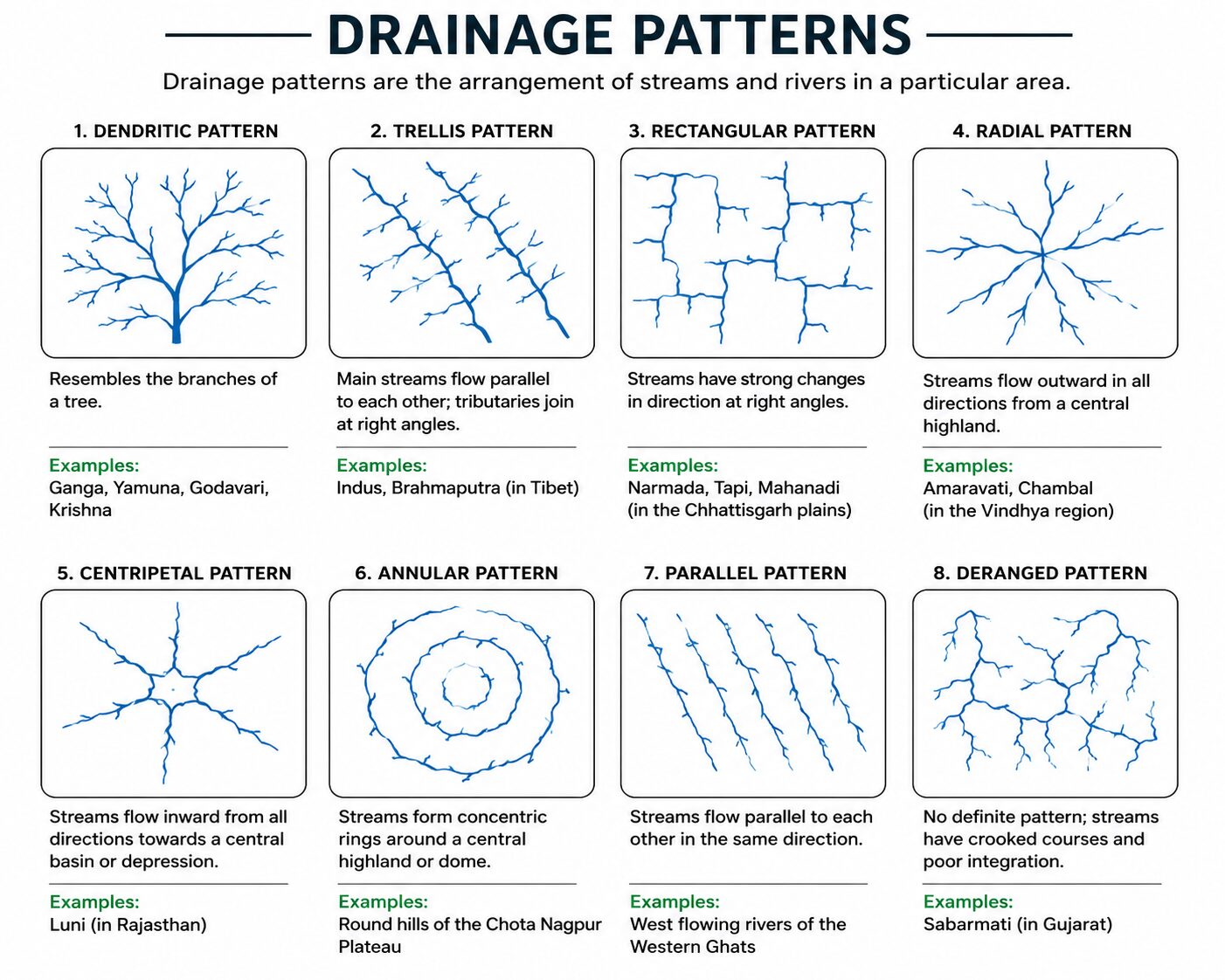
Before diving into specific River Systems of India, UPSC often tests the conceptual understanding of drainage patterns—the geometric arrangement of river channels in a landscape, governed by topography and underlying geology.
- Dendritic Pattern: Looks like the branches of a tree. Most rivers of the northern plains (Ganga, Yamuna) form this pattern as they flow over relatively uniform, flat slopes.
- Radial Pattern: Rivers originate from a central elevated point (a hill or dome) and flow outward in all directions. Example: Rivers originating from the Amarkantak Plateau (Narmada flowing west, Son flowing north, Mahanadi flowing east).
- Trellis Pattern: Primary tributaries flow parallel to each other, and secondary tributaries join them at right angles. Common in regions with parallel ridges and valleys (e.g., rivers in the upper Himalayan region).
- Centripetal Pattern: Rivers discharge their waters from all directions into a central lake or depression. Example: Streams flowing into Loktak Lake (Manipur).
Part 1: The Himalayan River Systems
The Himalayan drainage consists of three massive river basins: the Indus, the Ganga, and the Brahmaputra. These are antecedent rivers, meaning they existed before the Himalayas were fully formed. As the mountains rose, these rivers eroded the rock at the same pace, creating massive, deep V-shaped gorges.
1. The Indus River System
Known historically as the Sindhu, this system is deeply tied to the ancient Indus Valley Civilization and modern-day geopolitics.
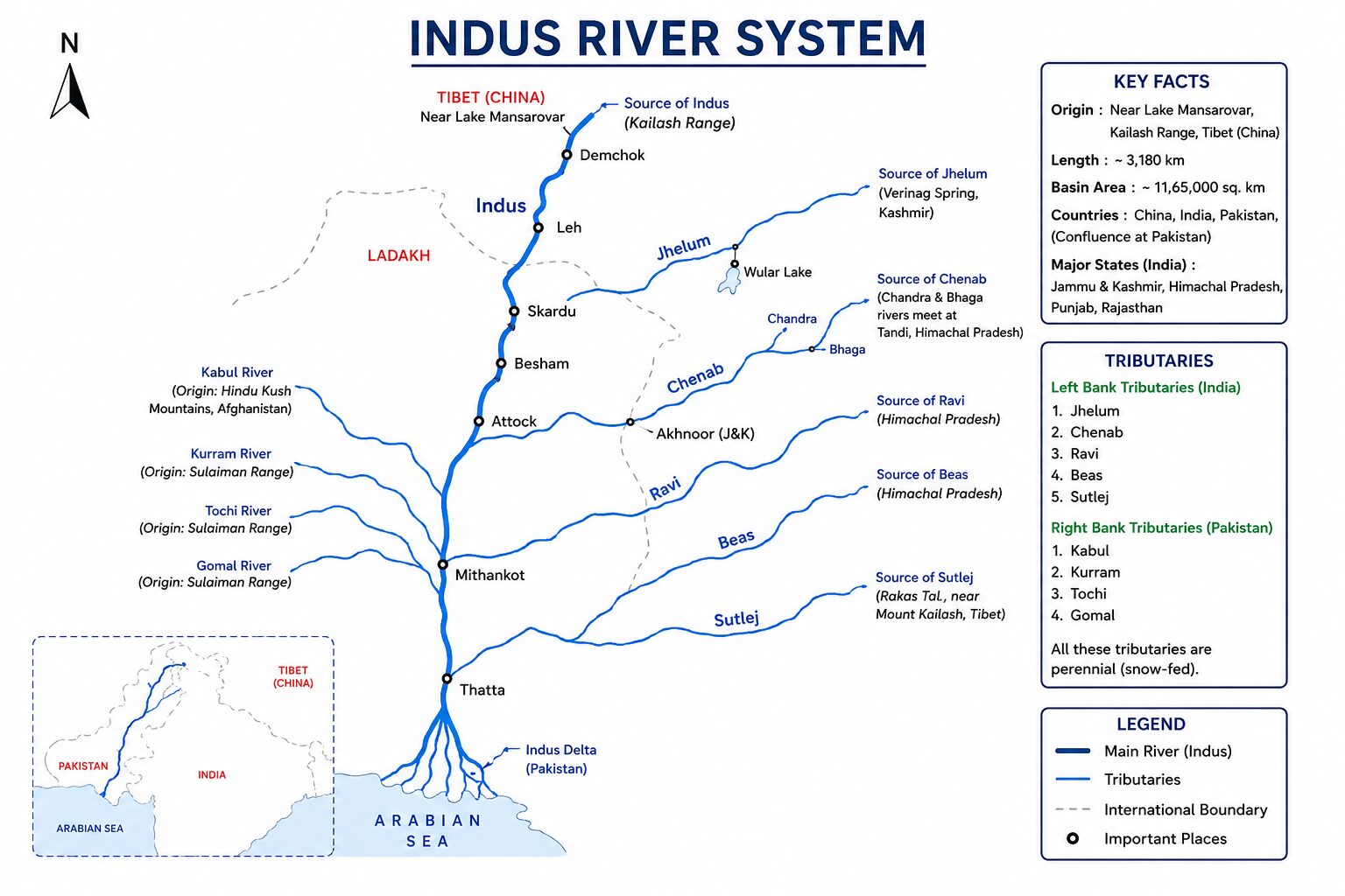
- Origin: Bokhar Chu glacier near Mansarovar Lake in Tibet (known locally as Singi Khamban or Lion’s Mouth).
- Total Length: 3,180 km (1,114 km within India).
- Course in India: Enters India near Demchok, flows between the Ladakh and Zanskar ranges, passes through the Leh district, and cuts a spectacular gorge near Nanga Parbat before entering Pakistan.
Major Tributaries (The “Punjab” Rivers):
| River | Origin | Key UPSC Facts & Dams |
| Jhelum | Verinag Spring (Pir Panjal) | Flows through Wular Lake; forms India-Pakistan border briefly. Uri Dam. |
| Chenab | Bara Lacha Pass (Himachal) | Largest tributary of Indus. Formed by Chandra and Bhaga rivers. Salal, Baglihar, and Dulhasti Hydroelectric Projects. |
| Ravi | Rohtang Pass (Kullu Hills) | Drains the area between Pir Panjal and Dhauladhar. Ranjit Sagar Dam (Thein Dam). |
| Beas | Beas Kund (near Rohtang) | Lies entirely within Indian territory. Meets Sutlej at Harike (Punjab). Pong Dam. |
| Sutlej | Rakas Lake (Tibet) | Antecedent river; enters India at Shipki La Pass. Feeds the Bhakra Nangal Dam (Govind Sagar reservoir). |
UPSC Mains Context: The Indus Water Treaty (1960)
Brokered by the World Bank, this treaty gives India exclusive control over the three eastern rivers (Ravi, Beas, Sutlej), while Pakistan controls the three western rivers (Indus, Jhelum, Chenab). However, India is allowed “non-consumptive” uses (like run-of-the-river hydroelectric projects) on the western rivers, which frequently leads to geopolitical friction.
Read Here: Indus River System in Full Details
2. The Ganga River System
The Ganga is the cultural and agricultural backbone of India, forming the largest river basin in the country.
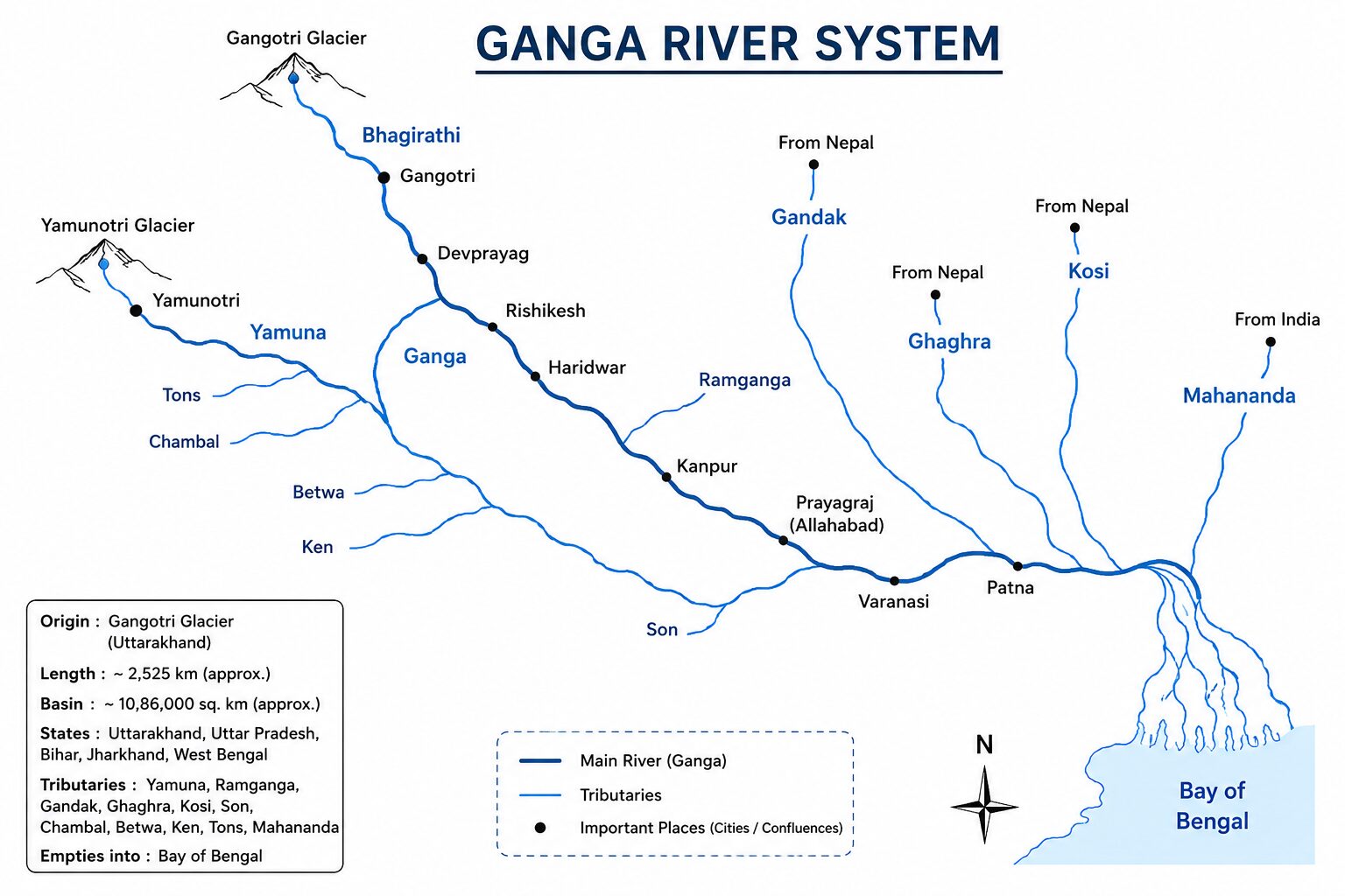
- Origin: Gangotri Glacier, Uttarakhand (originally known as the Bhagirathi).
- Length: 2,525 km (Longest river entirely within India).
- Discharge: Empties into the Bay of Bengal, forming the Sundarbans—the largest delta in the world, shared with the Brahmaputra.
The Panch Prayag (Uttarakhand Confluences)
Before entering the plains at Haridwar, the river system is formed by five sacred confluences:
- Vishnuprayag: Alaknanda + Dhauliganga
- Nandprayag: Alaknanda + Nandakini
- Karnaprayag: Alaknanda + Pindar
- Rudraprayag: Alaknanda + Mandakini
- Devprayag: Alaknanda + Bhagirathi (From here, it becomes the Ganga).
Tributaries of Ganga River:
- Yamuna: Longest and western-most tributary. Originates at Yamunotri glacier. Joins Ganga at Prayagraj. Its own major tributaries include the Chambal (known for badland topography/ravines), Sind, Betwa, and Ken.
- Ghaghara: Originates in glaciers of Mapchachugo. It is the largest tributary of the Ganga by water volume.
- Gandak: Formed by two streams (Kaligandaki and Trishulganga). Enters the Ganga plain in Bihar.
- Kosi: An antecedent river known as the “Sorrow of Bihar” due to its notorious shifting of courses and massive floods.
- Son: A major right-bank, south-to-north flowing river originating at the Amarkantak plateau.
- Damodar: Once known as the “Sorrow of Bengal,” now tamed by the Damodar Valley Corporation (DVC). It flows through a rift valley and joins the Hooghly (a distributary of Ganga).
Read Here: Ganga River System in Full Details
3. The Brahmaputra River System
Known for its braided channels, massive water volume, and immense hydroelectric potential.
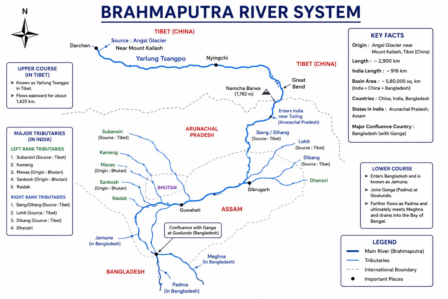
- Origin: Chemayungdung Glacier (Kailash range) near Mansarovar Lake, Tibet.
- Nomenclature:
- Tibet: Yarlung Tsangpo (meaning “The Purifier”)
- Arunachal Pradesh: Dihang or Siang
- Assam: Brahmaputra
- Bangladesh: Jamuna (eventually merges with Ganga/Padma to form the Meghna).
- Key Feature: Houses Majuli, the world’s largest riverine island (now heavily eroding).
Major Tributaries:
- Left Bank: Dibang, Lohit, Dhansiri, Kopili.
- Right Bank: Subansiri (largest tributary, antecedent), Kameng, Manas (flows through Manas National Park), Sankosh, Teesta (originates in Sikkim, subject of a major water dispute between India and Bangladesh).
Read Here: Brahmaputra River System in Full Details
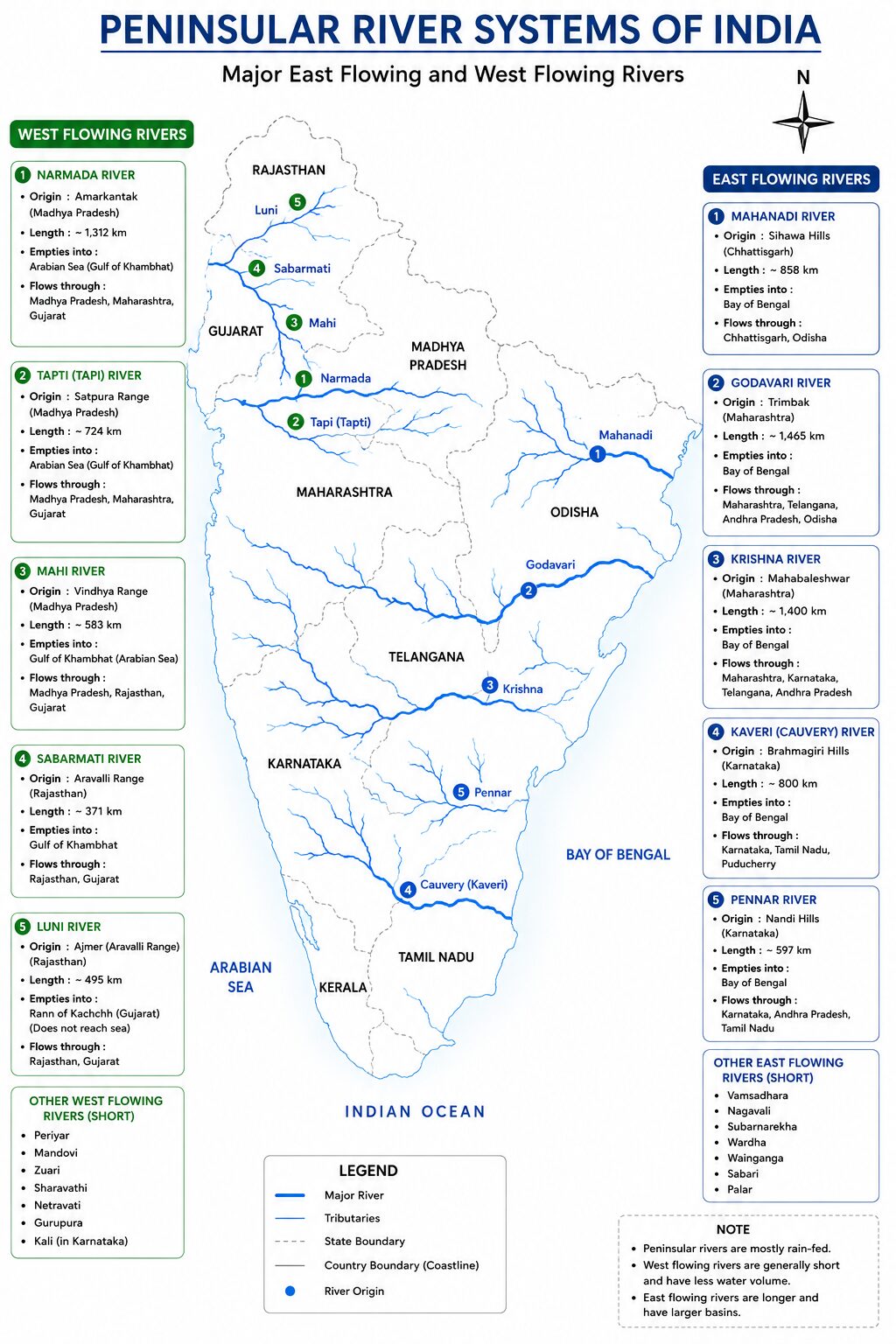
Part 2: The Peninsular River Systems (East-Flowing)
The Peninsular drainage is older, graded (reached their base level of erosion), and primarily oriented towards the Bay of Bengal due to the natural eastward tilt of the Deccan Plateau. They are characterized by broad, shallow valleys.
1. The Godavari River System (Dakshin Ganga)
- Origin: Trimbakeshwar, Nashik district (Maharashtra).
- Scale: Largest peninsular river system; covers ~10% of India’s total geographical area.
- Tributaries:
- Left Bank: Penganga, Wardha, Wainganga (these three combine to form the Pranhita), Indravati, Sabari.
- Right Bank: Manjira, Pravara.
- Major Projects: Polavaram Project, Kaleshwaram Lift Irrigation Project (one of the world’s largest multi-stage lift irrigation projects).
2. The Krishna River System
- Origin: Near Mahabaleshwar in the Western Ghats (Maharashtra).
- Tributaries: Tungabhadra (formed by Tunga and Bhadra), Bhima, Koyna, Ghataprabha, Malaprabha, Musi.
- Major Dams: Nagarjuna Sagar, Srisailam, Almatti.
- Disputes: The Krishna Water Disputes Tribunal (KWDT) manages complex, ongoing allocations between Maharashtra, Karnataka, Telangana, and Andhra Pradesh.
3. The Kaveri (Cauvery) River System
- Origin: Brahmagiri Hills, Kodagu (Coorg) district, Karnataka.
- Hydrological Anomaly: Unlike other peninsular rivers that dry up in winter, Kaveri maintains flow year-round. Its upper catchment (Karnataka) gets rain from the South-West monsoon (summer), while the lower catchment (Tamil Nadu) gets rain from the North-East monsoon (winter).
- Tributaries: Kabini, Bhavani, Amaravati, Hemavati, Arkavathi.
- Dispute: A highly sensitive century-old water sharing dispute primarily between Karnataka and Tamil Nadu.
4. The Mahanadi River System
- Origin: Sihawa in the Raipur district of Chhattisgarh.
- Tributaries: Seonath, Hasdeo, Mand, Ib (Left); Ong, Tel, Jonk (Right).
- Major Dam: Hirakud Dam (Odisha), the longest earthen dam in the world, crucial for flood control in the Mahanadi delta.
Part 3: The West-Flowing Peninsular Rivers
Rivers flowing west into the Arabian Sea are relatively short, swift, and do not form deltas. Instead, they form estuaries because they flow through hard rocks, carry less sediment, and have a steep gradient plunging into the sea.
1. Narmada & Tapi (The Rift Valley Twins)
- Narmada: Originates at the Amarkantak Plateau. It flows westward through a massive rift valley between the Vindhya (north) and Satpura (south) ranges. Forms the spectacular Dhuandhar falls near Jabalpur. Major dam: Sardar Sarovar.
- Tapi (Tapti): Originates in the Betul district (MP) in the Satpuras. Flows in a rift valley parallel to, and south of, the Narmada. Major dam: Ukai.
2. Mahi & Luni
- Mahi: Originates in the Vindhyas. Crucial UPSC Fact: It is the only river in India that crosses the Tropic of Cancer twice.
- Luni: An ephemeral, inland drainage river. It originates in the Aravallis (Pushkar valley), turns highly saline, and dissipates into the marshy Rann of Kutch without reaching the ocean.
Read Here: Peninsular Rivers of India Full Details
Part 4: Minor Rivers of India (High-Yield for Prelims)
UPSC frequently tests lesser-known rivers to filter candidates. Memorize these:
Minor East-Flowing Rivers
- Subarnarekha: Originates in the Ranchi Plateau; flows through Jamshedpur.
- Brahmani: Formed by the confluence of the Sankh and South Koel rivers in Odisha.
- Vamsadhara & Nagavali: Flow through Odisha and Andhra Pradesh (frequent subjects of water disputes).
- Palar: Flows through Karnataka, AP, and Tamil Nadu.
- Vaigai: Flows through Tamil Nadu; Madurai sits on its banks. Empties into the Palk Strait.
- Tambaraparani: A short, perennial river in southern Tamil Nadu, emptying into the Gulf of Mannar.
Minor West-Flowing Rivers (Sahyadri Streams)
- Shetruniji & Bhadra: Saurashtra region of Gujarat.
- Mandovi & Zuari: The lifelines of Goa. The famous Dudhsagar falls are located on the Mandovi.
- Sharavati: Karnataka; famous for the Jog Falls (plunge waterfall).
- Periyar: The longest river in Kerala (“Lifeline of Kerala”).
- Bharatpuzha (Ponnani): The second longest river in Kerala.
- Pamba: Kerala; flows near the Sabarimala temple.
Interlinking of Rivers in India (ILR)
A highly relevant Mains topic. The National Perspective Plan (NPP) aims to transfer water from water-surplus basins (like Brahmaputra/Ganga) to water-deficit basins (Peninsular India).
- Ken-Betwa Link: The first major project under ILR. Transfers water from the Ken river to the Betwa river to irrigate the drought-prone Bundelkhand region. Environmental concern: Submerges a portion of the Panna Tiger Reserve.
- Godavari-Krishna Link: Achieved locally in Andhra Pradesh via the Pattiseema Lift Irrigation Project.
Mnemonic Tricks to Memorize Indian Rivers
Don’t let Prelims options confuse you. Use these memory tricks:
1. Indus Tributaries (North to South):
- Trick: In June Car Runs By Swiftly.
- Decoding: Indus, Jhelum, Chenab, Ravi, Beas, Sutlej.
2. Ganga Left Bank Tributaries (West to East):
- Trick: Ram Gives Ghaghara to Gandak & Kosi in Mahananda.
- Decoding: Ramganga, Gomti, Ghaghara, Gandak, Kosi, Mahananda.
3. Major West-Flowing Rivers:
- Trick: NaTaMaLu
- Decoding: Narmada, Tapi, Mahi, Luni.
4. Krishna Tributaries:
- Trick: Bhima & Tungabhadra Met Koyna at the Ghats.
- Decoding: Bhima, Tungabhadra, Musi, Koyna, Ghataprabha.
UPSC Strategy Takeaway
When preparing for Geography, never study rivers in isolation. Always link them to:
- National Parks/Biospheres: Which river flows through Jim Corbett? (Ramganga). Which through Kaziranga? (Brahmaputra).
- Topography: Why do west-flowing rivers not form deltas? (Steep gradients, hard rock beds).
- Current Affairs: Are there active water dispute tribunals (Article 262) in the news? Is a new dam causing ecological concerns?
Read this as well. It’s important: Explore List of all Important Dams in India
