
Brahmaputra River System
The Brahmaputra River System is one of the most voluminous and mighty river basins in the world. For UPSC aspirants, it represents a critical intersection of physical geography, rich biodiversity, severe disaster management challenges (Assam floods), and complex trans-boundary hydro-politics with China and Bangladesh.
This comprehensive guide breaks down its entire course, tributary network, ecological significance, and the massive infrastructural projects shaping its future.
Read about all the river systems of India Here
Geographical Overview of the Brahmaputra River System
The Brahmaputra is a classic example of an antecedent river (older than the Himalayas) and is known for its highly braided channels, shifting sandbanks, and massive sediment load.
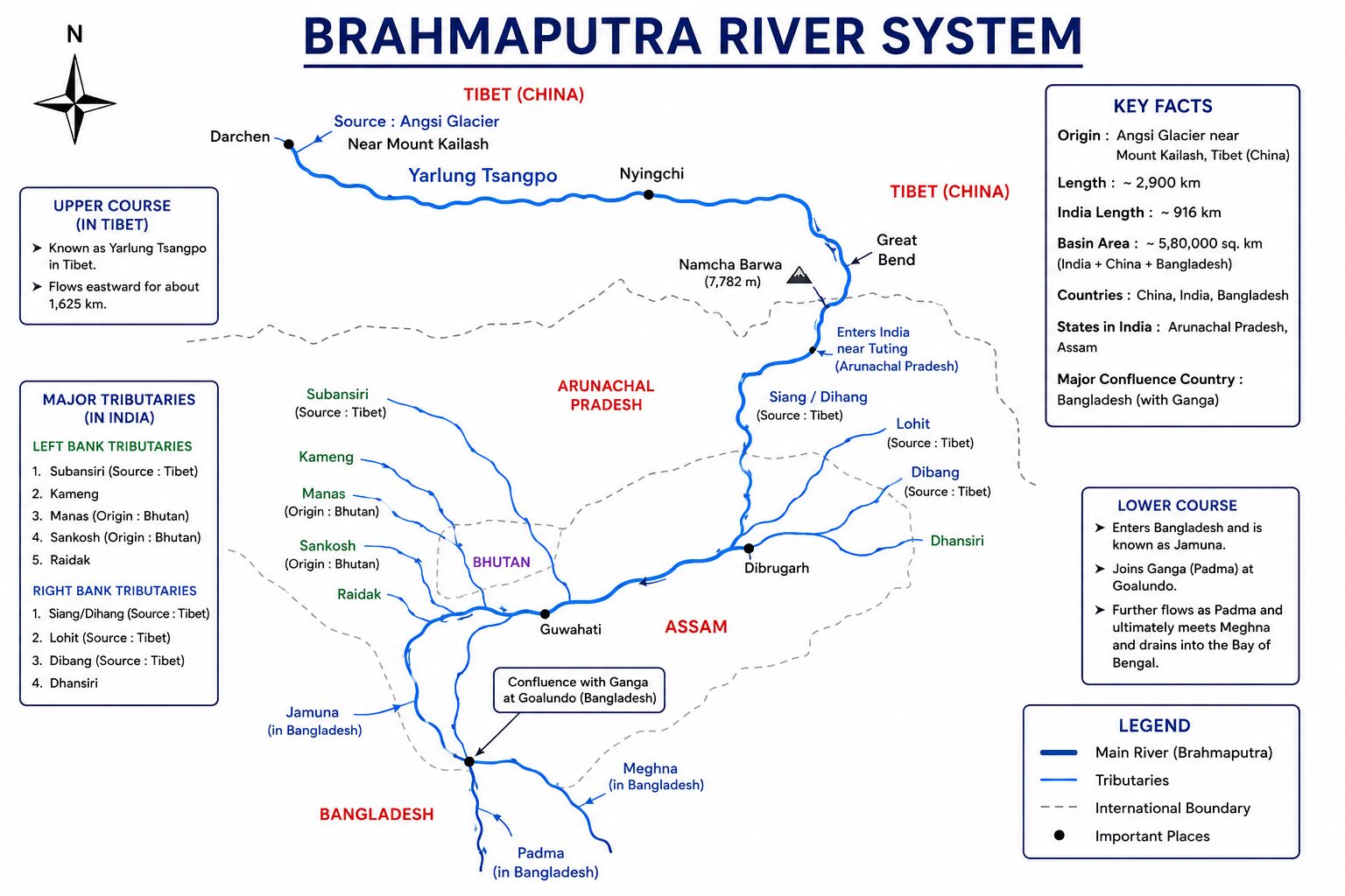
- Origin: Chemayungdung Glacier of the Kailash range, near the Mansarovar Lake in Tibet.
- Total Length: Approximately 2,900 km (making it one of the longest in Asia).
- Length in India: About 916 km.
- Nomenclature Across Regions:
- Tibet: Yarlung Tsangpo (meaning “The Purifier”).
- Arunachal Pradesh: Dihang or Siang.
- Assam: Brahmaputra (formed after the Dihang meets the Dibang and Lohit).
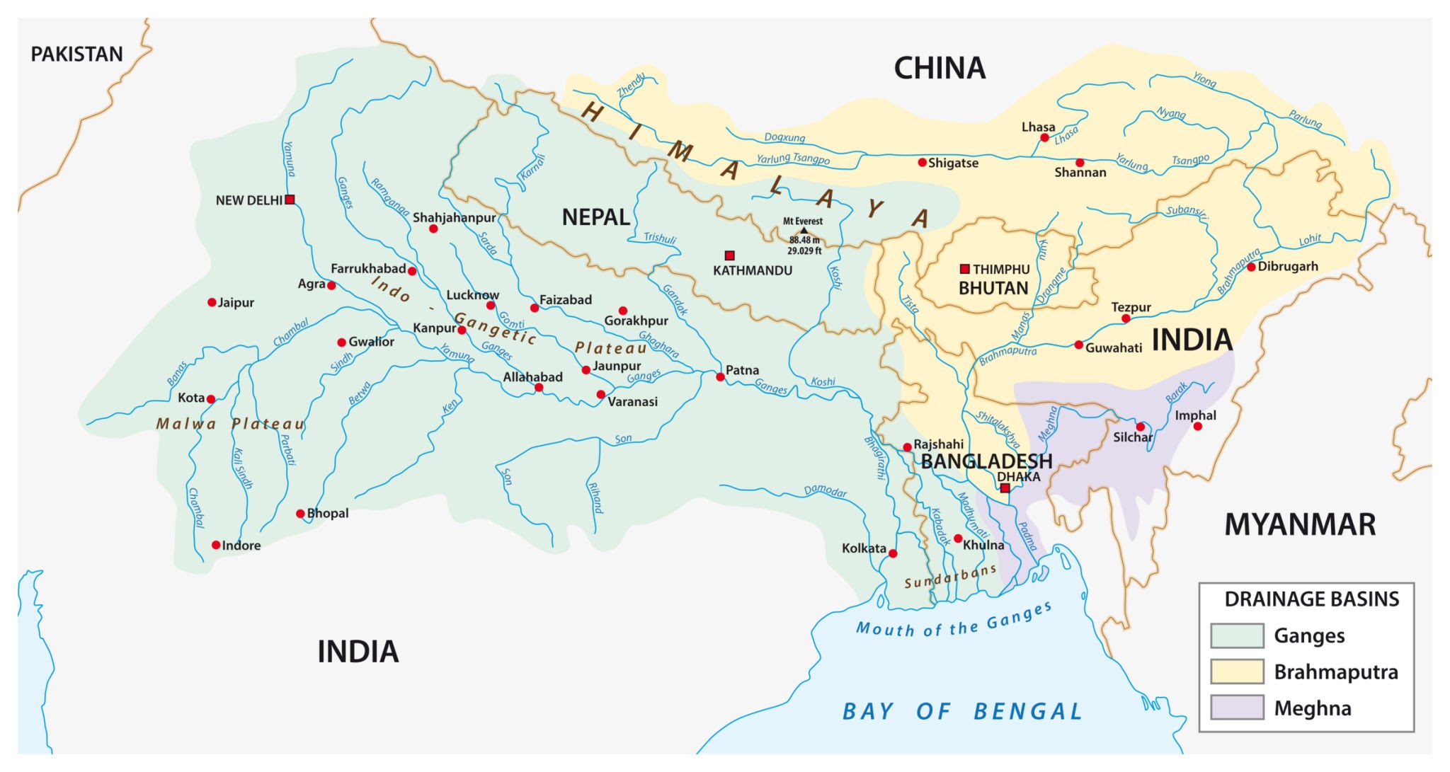
- Bangladesh: Jamuna (eventually merges with the Ganga/Padma and empties into the Bay of Bengal as the Meghna).
The Great U-Turn (Hairpin Bend):
In Tibet, the Tsangpo flows eastwards parallel to the Himalayas for nearly 1,200 km. It then takes a dramatic, sharp southward U-turn around the towering Namcha Barwa peak to cut a deep gorge and enter Arunachal Pradesh, India.
Major Tributaries of the Brahmaputra
The major right and left bank tributaries of the Brahmaputra are following:
Right Bank Tributaries (Himalayan Origins)
These rivers bring massive amounts of coarse sediment and water from the Himalayas, contributing significantly to the river’s braided nature.
- Subansiri: The largest tributary of the Brahmaputra. It is an antecedent river originating in Tibet and is known as the “Gold River.”
- Kameng: Also known as the Jia Bhoreli in Assam. The famous Pakhui (Pakke) Tiger Reserve is located on its banks.
- Manas: An antecedent trans-boundary river flowing from Bhutan. It flows straight through the Manas National Park.
- Sankosh: Forms the boundary between Assam and West Bengal.
- Teesta: Originates from the Zemu Glacier in Sikkim. It carved out the deep Teesta Valley and is the lifeline of Sikkim before entering Bangladesh to join the Brahmaputra.
Left Bank Tributaries (Naga-Patkai Origins)
- Dibang: Originates in the Mishmi Hills of Arunachal Pradesh.
- Lohit: Known as the “River of Blood” due to its lateritic (red) soil composition. The famous Bhupen Hazarika Setu (Dhola-Sadiya bridge, India’s longest river bridge) is built across it.
- Dhansiri: Originates in the Laisang peak of Nagaland and flows through the Kaziranga National Park.
- Kopili: Known for acidic waters due to unscientific rat-hole coal mining in the Meghalaya plateau.
Biodiversity and Ecology of the Brahmaputra Basin
The Brahmaputra valley is a global biodiversity hotspot, hosting lush semi-evergreen forests, wet grasslands, and iconic riverine islands.
1. Majuli: The Sinking Island
Majuli, located in Assam, is the largest riverine island in the world and India’s first island district.
- Formation: It was formed by historical shifts in the course of the Brahmaputra and its tributaries, primarily the Subansiri.
- Ecology & Culture: It is the hub of Assamese neo-Vaishnavite culture (Sattras).
- Threat: Majuli is shrinking rapidly due to severe bank erosion and annual flooding. It has lost roughly a third of its landmass in the last century.
2. Kaziranga National Park
A UNESCO World Heritage Site located on the floodplains of the Brahmaputra. The annual floods are essential for Kaziranga; they wash away invasive weeds and replenish the wetlands (beels) that sustain the Great One-Horned Rhinoceros and the Wild Water Buffalo.
3. The Ganges River Dolphin (Susu)
Though named after the Ganga, this endangered, blind, echolocating freshwater dolphin is deeply native to the Brahmaputra river as well.
Major Hydroelectric & Development Projects
The Brahmaputra basin holds India’s highest untapped hydroelectric potential, but development is hindered by the region’s intense seismicity and fragile ecology.
- Subansiri Lower Hydroelectric Project (2,000 MW): Located on the Assam-Arunachal border. It is India’s largest under-construction run-of-the-river project, though it has faced massive delays due to anti-dam protests and landslide concerns.
- Dibang Multipurpose Project (2,880 MW): A massive gravity dam planned in Arunachal Pradesh. Once completed, it will be the highest dam in India, serving both power generation and critical flood moderation for Assam.
- National Waterway 2 (NW-2): The 891 km stretch of the Brahmaputra from Sadiya to Dhubri in Assam. It is crucial for the “Act East Policy” to connect Northeast India to the Bay of Bengal via Indo-Bangladesh protocol routes.
- Bogibeel Bridge: India’s longest rail-cum-road bridge, providing immense strategic mobility to the defense forces moving toward the China border.
Trans-Boundary Conflicts: The China and Bangladesh Factors
1. The China Threat (Upper Riparian Hegemony)
China does not have a formal water-sharing treaty with India for the Brahmaputra.
- Damming the Tsangpo: China has operationalized the Zangmu Dam and is planning a massive “super dam” at the Great Bend (Motuo) just before the river enters India. India fears this could be used as a geopolitical weapon to either choke off water during dry seasons or release sudden flash floods.
- Data Sharing: Under MoUs, China provides hydrological data during the monsoon to help India predict floods. However, during the 2017 Doklam standoff, China abruptly stopped sharing this data.
2. Teesta Water Dispute (India and Bangladesh)
The Teesta is a major tributary of the Brahmaputra. Bangladesh, as the lower riparian state, demands an equal (50-50) share of the Teesta waters during the lean winter months. India (specifically the state government of West Bengal) argues that giving away more water will leave northern West Bengal severely drought-stricken. The treaty remains unsigned, acting as a major diplomatic irritant.
Read Here: Ganga River System
Read Here: Indus River System