

Mountain Ranges of Deccan and South India
While the mighty Himalayas dominate the northern frontiers of India with their towering, snow-clad, geologically young fold mountains, the peninsular region tells a much older, geologically stable story. The mountain ranges of the Deccan Plateau and South India are ancient and heavily eroded, representing relics of tectonic events that occurred hundreds of millions of years ago.
For UPSC Civil Services aspirants, understanding the topography of Peninsular India is critical. These mountain systems dictate monsoon rainfall patterns, serve as colossal water divides for India’s major rivers, host globally recognized biodiversity hotspots, and are home to ancient indigenous communities. This comprehensive guide breaks down the geological formation, regional alignments, major peaks, strategic passes, and ecological significance of the Central, Deccan, and South Indian mountain ranges.
Geological Evolution of Peninsular Mountains
Unlike the Himalayas, which are young fold mountains formed by active continental collision, the mountains of the Indian Peninsula are primarily relict mountains (mountains of circumdenudation) and block mountains.
- Relict Mountains: Ranges like the Aravallis, Vindhyas, and the Eastern Ghats were once massive fold mountains formed during the Precambrian era. Over millions of years, they have been denuded (worn down) by weathering and river erosion. Today, they stand as highly dissected, residual hills.
- Block Mountains: Ranges like the Satpuras are block mountains, formed when massive tectonic rifting caused sections of the earth’s crust to subside (forming rift valleys like those of the Narmada and Tapi), leaving the elevated blocks standing as mountains.
- Escarpments: The Western Ghats are not true folded mountains. Geologically, they are the fault escarpment (a steep cliff) of the Deccan Plateau, formed when a massive chunk of the ancient Gondwanaland fractured and subsided into the Arabian Sea during the late Jurassic to early Cretaceous periods.
The Central Indian Ranges: The Northern Boundary
The northern boundary of the Deccan Plateau is guarded by ancient, east-west aligned mountain systems that act as India’s most significant geographic and cultural water divide, separating Northern India from Peninsular India.
1. The Aravalli Range
- Geological Age: The Aravallis are one of the oldest fold mountain systems in the world, dating back to the Precambrian era (over 2 billion years ago). Today, they exist purely as relict mountains.
- Alignment: Stretching approximately 800 kilometers from Palanpur in Gujarat, traversing through Rajasthan, and terminating at the Delhi Ridge (Raisina Hill).
- Highest Peak: Guru Shikhar (1,722 meters), located in the Mount Abu region of Rajasthan.
- Geographical Significance: The Aravallis act as a climatic barrier. Because their alignment is parallel to the direction of the Arabian Sea branch of the Southwest Monsoon, they fail to intercept the rain-bearing winds, resulting in the arid formation of the Thar Desert to their west.
- Origin of Rivers: Acts as a water divide between the Indus basin and the Ganga basin. The Luni river originates in the Pushkar valley of the Aravallis, while the Banas and Sabarmati also trace their origins here.
2. The Vindhya Range
- Geological Profile: A complex, discontinuous chain of mountain ridges, hill ranges, and plateau escarpments formed purely of sedimentary rocks (sandstone, shale, and limestone). They act as a classic escarpment rather than a true mountain building range.
- Alignment: Extending from Gujarat in the west, running parallel to the Narmada valley through Madhya Pradesh, and extending into Uttar Pradesh and Bihar (as the Kaimur Range).
- Highest Peak: Sadbhawna Shikhar (Goodwill Peak) at 752 meters.
- Geographical Significance: The Vindhyas historically act as the traditional geographical and cultural boundary between North India and South India. They form a primary water divide, directing rivers like the Chambal, Betwa, and Ken northwards to join the Yamuna-Ganga system.
3. The Satpura Range
- Geological Profile: The name translates to “Seven Folds.” The Satpuras are a classic example of Block Mountains (Horst), flanked by two massive tectonic rift valleys (Graben) housing the Narmada river to the north and the Tapi river to the south.
- Alignment: Running east-west across Gujarat, Maharashtra, Madhya Pradesh, and Chhattisgarh. It is composed of multiple sub-ranges: the Rajpipla Hills (west), the Mahadeo Hills (center), and the Maikal Range (east).
- Highest Peak: Dhupgarh (1,350 meters), located near the Pachmarhi hill station in the Mahadeo Hills.
- Origin of Rivers: The Amarkantak Plateau (in the Maikal Range) is a remarkable radial drainage hub, giving birth to the west-flowing Narmada and the north-flowing Son river. The Tapi river originates from Multai in the Betul plateau of the Satpuras.
The Western Ghats (Sahyadris)
The Western Ghats run parallel to the western coast of the Indian peninsula, forming an unbroken, towering wall from the mouth of the Tapi river down to Kanyakumari. Recognizing their immense biological diversity, UNESCO declared the Western Ghats a World Heritage Site, and they are one of the world’s eight “hottest hotspots” of biological diversity.
- Length: Approximately 1,600 kilometers.
- Average Elevation: Rises gradually from 1,000 meters in the north to over 2,000 meters in the south.
- Topographic Nature: Unlike the fragmented Eastern Ghats, the Western Ghats form a continuous escarpment that can only be crossed through specific mountain passes.
Regional Division of the Western Ghats
1. Northern Western Ghats (Maharashtra and Gujarat):
- Characteristics: Covered by horizontal sheets of basaltic lava (Deccan Traps). The elevation is relatively lower.
- Major Peaks: Kalsubai (1,646 meters), the highest peak in Maharashtra; Salher; and Mahabaleshwar.
- Rivers: Major peninsular rivers like the Godavari (from Trimbakeshwar) and the Krishna (from Mahabaleshwar) originate here.
2. Middle Western Ghats (Karnataka and Goa):
- Characteristics: The basaltic lava gives way to granites and gneisses. The terrain becomes heavily forested and rugged.
- Major Sub-Ranges: Baba Budan Hills (famous for India’s first coffee plantations) and the Kudremukh ranges.
- Major Peaks: Mullayanagiri (1,930 meters) and Kudremukh (1,892 meters).
- Rivers: The Sharavati river, which creates the spectacular Jog Falls, flows through this region.
3. Southern Western Ghats (Kerala and Tamil Nadu):
- Characteristics: This is the most elevated, structurally complex, and biodiverse section of the Ghats, lying south of the Palghat Gap.
- Major Sub-Ranges: Anamalai Hills, Cardamom Hills (Elamalai), and Agasthyamalai Hills.
- Highest Peak: Anaimudi (2,695 meters) located in the Anamalai Hills. It is the highest peak in Peninsular India.
Strategic Mountain Passes of the Western Ghats
UPSC frequently tests the precise geographical connectivity of these crucial passes:
- Thal Ghat (Kasara Ghat): Connects Mumbai to Nashik (and onwards to Kolkata/Delhi).
- Bhor Ghat: Connects Mumbai to Pune (and onwards to Chennai/Hyderabad).
- Pal Ghat (Palakkad Gap): The largest gap in the Western Ghats. It separates the Nilgiris from the Anamalai Hills, connecting Kochi (Kerala) to Coimbatore (Tamil Nadu).
- Shencottah Gap: Located in the far south, connecting Kollam (Kerala) to Madurai (Tamil Nadu).
The Eastern Ghats
Unlike the towering, continuous wall of the Western Ghats, the Eastern Ghats are a discontinuous, highly fragmented, and lower-elevation chain of relict mountains running parallel to the Bay of Bengal.
- Geological Profile: The Eastern Ghats are older than the Western Ghats. Over millions of years, mighty east-flowing antecedent-like rivers (Godavari, Krishna, Mahanadi, and Kaveri) have eroded and sliced through these mountains, breaking them into isolated hill complexes.
- Alignment: Stretching from the Mahanadi basin in Odisha down to the Nilgiris in Tamil Nadu.
- Highest Peak: Jindhagada Peak (1,690 meters) in the Araku Valley of Andhra Pradesh. Arma Konda (1,680 meters) and Mahendragiri (1,501 meters) are other prominent summits.
Major Hill Sub-Ranges of the Eastern Ghats (North to South)
Aspirants must memorize the exact north-to-south sequence of these fragmented hills, heavily located in Andhra Pradesh and Tamil Nadu:
- Nallamala Hills: Located south of the Krishna river in Andhra Pradesh. Composed of quartzites and slates.
- Palkonda Range: Andhra Pradesh, known for the Tirupati temple.
- Velikonda Range: Andhra Pradesh, situated structurally behind the Coromandel coast.
- Javadi Hills: Northern Tamil Nadu. Composed of bluish-grey granites.
- Shevaroy Hills: Tamil Nadu, famous for the Yercaud hill station.
- Panchamalai & Sirumalai: Lower elevation hills extending towards southern Tamil Nadu.
The Southern Mountain Knot: The Convergence Zone
The true architectural majesty of South India’s geography lies in the convergence zone where the Western Ghats and the Eastern Ghats meet, creating a massive high-altitude mountain knot.
1. The Nilgiri Hills (Blue Mountains)
- Convergence Point: The exact meeting point of the Eastern and Western Ghats.
- Highest Peak: Doddabetta (2,637 meters).
- Ecology: Home to the Nilgiri Biosphere Reserve, India’s first designated biosphere. Famous for the Shola forests—stunted tropical montane evergreen forests found in valleys interspersed with rolling grasslands.
- Tribal Communities: Historically inhabited by indigenous pastoral tribes, most notably the Toda tribe, known for their unique barrel-shaped huts and buffalo herding.
2. The Anamalai and Cardamom Hills
- South of the Palghat Gap, the Western Ghats rise again dramatically to form the Anamalai (Elephant) Hills, housing Peninsular India’s highest peak, Anaimudi (2,695m).
- From the Anaimudi node, three mountain ranges radiate in different directions:
- Anamalai Hills to the north.
- Palani Hills to the northeast (into Tamil Nadu, housing the Kodaikanal hill station).
- Cardamom Hills (Elamalai) to the south. These are the southernmost mountain ranges of India, famous for globally prized pepper and cardamom plantations.
Minor Ranges of the Deccan Plateau
The interior of the Deccan Plateau itself features several low-elevation, distinct hill ranges that act as local watersheds:
- Ajanta Range: Entirely within Maharashtra. Formed by basaltic lava flows. Houses the famous UNESCO-listed Ajanta Caves.
- Balaghat Range: Acts as a water divide between the Godavari and Bhima rivers in Maharashtra.
- Harishchandra Range: Located in Maharashtra, acting as a crucial watershed separating the Godavari and Krishna river basins.
- Garhjat Hills: Located in Chhattisgarh and Odisha, housing dense forests and rich mineral reserves (iron ore and coal).
Geomorphological Features & Vegetation of South Indian Mountains
1. The Rain Shadow Effect
The Western Ghats stand perpendicular to the Southwest Monsoon winds coming from the Arabian Sea. As these moisture-laden winds hit the western slopes, they are forced to rise, causing massive orographic precipitation (often exceeding 250 cm) on the windward side (Konkan, Malabar coasts). However, as the winds cross the peaks and descend into the Deccan Plateau, they compress, warm up, and lose their moisture. This creates a massive Rain Shadow Zone on the leeward side (interior Maharashtra, North Karnataka, and Telangana), resulting in semi-arid and drought-prone conditions.
2. Shola Forests and Biodiversity
Above 1,500 meters in the Nilgiris, Anamalai, and Palani hills, a highly unique ecosystem exists known as the Shola-Grassland complex. Sholas are patches of stunted, dense, tropical montane evergreen forests nestled in the valleys and folds of the mountains, completely surrounded by undulating montane grasslands. This ecosystem is extremely sensitive to climate change and fires. It is the exclusive habitat of the endangered Nilgiri Tahr and the Lion-tailed Macaque.
3. Lateritic Soil Profiles
The summits of the Sahyadris and the Eastern Ghats experience high temperatures combined with alternate wet and dry spells. This intense climatic weathering leads to the leaching of silica, leaving behind soils rich in iron and aluminum oxides known as Laterite soil. This soil profile is inherently infertile for basic agriculture but provides excellent conditions for plantation crops like cashew, rubber, tea, and coffee.
UPSC Memory Tricks & Mnemonic Frameworks
To rapidly recall the exact spatial arrangement of the Peninsular ranges during Prelims, use these mnemonics:
1. North to South Sequence of Eastern Ghats Hills
- Mnemonic Phrase: Never Put Jam Sauce on Pizza.
- Decoding:
- N -> Nallamala Hills (AP)
- P -> Palkonda Range (AP)
- J -> Javadi Hills (TN)
- S -> Shevaroy Hills (TN)
- P -> Panchamalai Hills (TN)
2. West to East Sequence of Central Indian Ranges
- Mnemonic Phrase: Very Mighty Shiva Made Mountains.
- Decoding:
- V -> Vindhya Range
- M -> Mahadeo Hills
- S -> Satpura Range (Main)
- M -> Maikal Range
- M -> Mahadeo / Rajmahal Hills (Moving further east into Jharkhand).
3. Sequence of Western Ghats Passes (North to South)
- Mnemonic Phrase: Tall Boys Play Sports.
- Decoding:
- T -> Thal Ghat (Mumbai – Nashik)
- B -> Bhor Ghat (Mumbai – Pune)
- P -> Pal Ghat (Kerala – Tamil Nadu)
- S -> Shencottah Pass (Kollam – Madurai)
Important Facts for Exams (UPSC/UPPSC/State PSC Prelims Highlights)
- Highest Peak in Peninsular India: Anaimudi (2,695m) in the Anamalai Hills, Kerala.
- Highest Peak in Eastern Ghats: Jindhagada Peak (1,690m) in the Araku Valley, Andhra Pradesh.
- Highest Peak in Aravallis: Guru Shikhar (1,722m) at Mount Abu, Rajasthan.
- Highest Peak in Satpuras: Dhupgarh (1,350m) in the Mahadeo Hills, Madhya Pradesh.
- Highest Peak in the Nilgiris: Doddabetta (2,637m), Tamil Nadu.
- Meeting Point of the Ghats: The Eastern and Western Ghats converge at the Nilgiri Mountain knot.
- Geological Structure of Aravallis: Relict mountains originating from the Precambrian era, one of the oldest landmasses on Earth.
- Satpura Tectonics: They are block mountains located between the rift valleys of the Narmada (north) and Tapi (south) rivers.
- Endemic Biodiversity: The Western Ghats are a global biodiversity hotspot housing endemic species like the Nilgiri Tahr, Lion-tailed Macaque, and the Purple Frog.
- Shola Forests: Specialized stunted montane evergreen forests found in the high-altitude valleys of the Nilgiris, Palani, and Anamalai hills.
- Tropic of Cancer: The Mahi River, originating in the Vindhya range, is the only river in India that intersects the Tropic of Cancer twice.
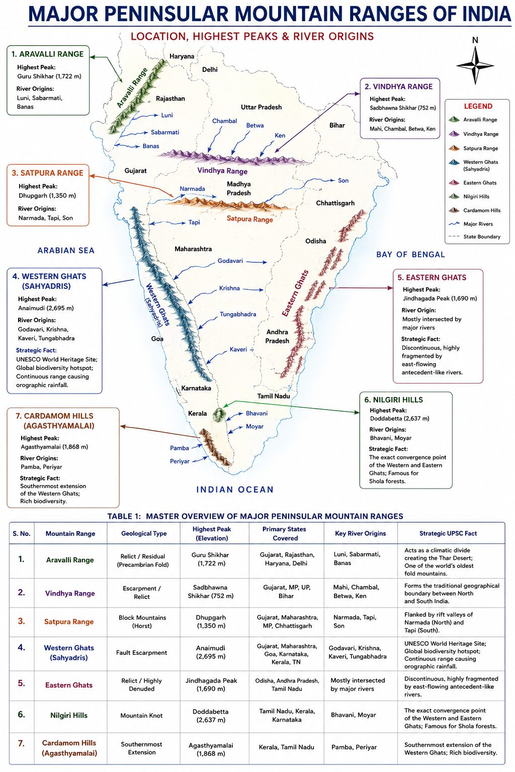
Revision Table 1: Overview of Major Peninsular Mountain Ranges
| Mountain Range | Geological Type | Highest Peak (Elevation) | Primary States Covered | Key River Origins | Facts |
| Aravalli Range | Relict / Residual (Precambrian Fold) | Guru Shikhar (1,722 m) | Gujarat, Rajasthan, Haryana, Delhi | Luni, Sabarmati, Banas | Acts as a climatic divide creating the Thar Desert; One of the world’s oldest fold mountains. |
| Vindhya Range | Escarpment / Relict | Sadbhawna Shikhar (752 m) | Gujarat, MP, UP, Bihar | Mahi, Chambal, Betwa, Ken | Forms the traditional geographical boundary between North and South India. |
| Satpura Range | Block Mountains (Horst) | Dhupgarh (1,350 m) | Gujarat, Maharashtra, MP, Chhattisgarh | Narmada, Tapi, Son | Flanked by rift valleys of Narmada (North) and Tapi (South). |
| Western Ghats (Sahyadris) | Fault Escarpment | Anaimudi (2,695 m) | Gujarat, Maharashtra, Goa, Karnataka, Kerala, TN | Godavari, Krishna, Kaveri, Tungabhadra | UNESCO World Heritage Site; Global biodiversity hotspot; Continuous range causing orographic rainfall. |
| Eastern Ghats | Relict / Highly Denuded | Jindhagada Peak (1,690 m) | Odisha, Andhra Pradesh, Tamil Nadu | Mostly intersected by major rivers | Discontinuous, highly fragmented by east-flowing antecedent-like rivers. |
| Nilgiri Hills | Mountain Knot | Doddabetta (2,637 m) | Tamil Nadu, Kerala, Karnataka | Bhavani, Moyar | The exact convergence point of the Western and Eastern Ghats; Famous for Shola forests. |
| Cardamom Hills | Southernmost Extension | Agasthyamalai (1,868 m) | Kerala, Tamil Nadu | Pamba, Periyar | Southernmost mountain range of India; Famous for spices (pepper, cardamom). |
Revision Table 2: Western Ghats vs. Eastern Ghats (Comparison)
| Feature | Western Ghats (Sahyadris) | Eastern Ghats |
| Continuity | Continuous; can only be crossed through distinct mountain passes (Ghats). | Discontinuous and fragmented; severely eroded by major east-flowing rivers. |
| Elevation | Higher average elevation (900m to 1,600m); elevation increases from North to South. | Lower average elevation (600m to 900m). |
| Highest Peak | Anaimudi (2,695 m) located in the Anamalai Hills, Kerala. | Jindhagada Peak (1,690 m) located in the Araku Valley, Andhra Pradesh. |
| Rainfall & Climate | Faces the Arabian Sea monsoon directly, resulting in heavy orographic rainfall (>250 cm). | Lies almost parallel to the retreating monsoon; receives comparatively lower rainfall. |
| Vegetation | Tropical evergreen and semi-evergreen forests; Shola forests at higher altitudes. | Mostly tropical moist deciduous and dry deciduous forests. |
| Geological Formation | Formed due to the faulting and subsidence of the Arabian Sea block during the Gondwanaland breakup. | Ancient fold mountains that have been subjected to extensive denudation and weathering. |
Revision Table 3: Strategic Mountain Passes of Peninsular India
Mountain passes (locally called Ghats) are highly favored by the UPSC for match-the-following questions.
| Pass Name | Mountain Range | Connects (Strategic Route) | Key Geographical Fact |
| Thal Ghat (Kasara Ghat) | Western Ghats (North) | Mumbai to Nashik | Major road and rail route connecting Mumbai to Delhi and Kolkata. |
| Bhor Ghat | Western Ghats (Central) | Mumbai to Pune | Historic trade route connecting the Konkan coast to the Deccan plateau. |
| Pal Ghat (Palakkad Gap) | Western Ghats (South) | Kochi (Kerala) to Coimbatore (TN) | Largest gap in the Western Ghats; separates the Nilgiris from the Anamalai hills. |
| Shencottah Gap | Western Ghats (Deep South) | Kollam (Kerala) to Madurai (TN) | Located between the Cardamom hills and the Agasthyamalai hills. |
| Haldighati Pass | Aravalli Range | Rajsamand to Pali (Rajasthan) | Historic site of the Battle of Haldighati (1576); known for its turmeric-colored soil. |
Revision Table 4: Important Hill Alignments (North to South)
UPSC frequently asks aspirants to arrange hills from North to South. Use these tables for exact chronological mapping.
A. Hills of the Eastern Ghats & Coromandel Coast
Mnemonic: Never Put Jam Sauce on Pizza.
- Nallamala Hills (Andhra Pradesh)
- Palkonda Range (Andhra Pradesh)
- Javadi Hills (Tamil Nadu)
- Shevaroy Hills (Tamil Nadu)
- Panchamalai Hills (Tamil Nadu)
- Sirumalai Hills (Tamil Nadu)
- Palani Hills (Tamil Nadu – technically an eastward offshoot of the Western Ghats)
B. The Southern Mountain Knot Complex
Moving South from the Palghat Gap:
- Nilgiri Hills (Meeting point of Eastern & Western Ghats)
- (Palghat Gap interrupts the range)
- Anamalai Hills (Houses Anaimudi peak)
- Cardamom Hills (Elamalai – Further South)
- Agasthyamalai Hills (Deepest South)
Revision Table 5: Top 5 Highest Peaks of Peninsular India
| Rank | Peak Name | Elevation | Mountain Range | State |
| 1 | Anaimudi | 2,695 m | Anamalai Hills (Western Ghats) | Kerala |
| 2 | Doddabetta | 2,637 m | Nilgiri Hills | Tamil Nadu |
| 3 | Kolaribetta | 2,629 m | Mukurthi National Park (Nilgiris) | Tamil Nadu |
| 4 | Makurti (Mukurthi) | 2,554 m | Nilgiri Hills | Tamil Nadu |
| 5 | Vandaravu | 2,553 m | Palani Hills | Tamil Nadu |

Checkout Indian Geography Notes Page for all Topics for Indian Geography and Free Notes PDF Download.