

Indus River System
The Indus River System is one of the largest and most historically significant river basins in the world. As the cradle of the ancient Indus Valley Civilization, it holds immense cultural weight. For the modern UPSC aspirant, it is a high-yield topic encompassing geography, ecology, and the sensitive geopolitics of the Indus Water Treaty (1960).
This comprehensive guide breaks down the origin, geographical course, major and minor tributaries, massive hydroelectric projects, and the unique biodiversity of the Indus Basin.
Indus River System: Geographical Overview
The Indus (historically known as the Sindhu) is an antecedent river, meaning it existed before the upliftment of the Himalayas. As the mountains rose, the Indus cut through them, creating massive, deep gorges.
- Origin: The river originates from a glacier near Bokhar Chu in the Kailash Mountain range, close to Mansarovar Lake in Tibet. In Tibet, it is known as Singi Khamban (Lion’s Mouth).
- Total Length: Approximately 3,180 km (making it one of the longest rivers in Asia).
- Length in India: 1,114 km.
- Course in India: It enters India near Demchok in Ladakh. It flows strictly northwest between the Ladakh and Zanskar mountain ranges. It passes through the Leh district and cuts a spectacular 5,100-meter deep gorge near Nanga Parbat before entering Gilgit-Baltistan and subsequently Pakistan.
- Discharge: It flows southwards through Pakistan and forms a massive delta before emptying into the Arabian Sea near Karachi.
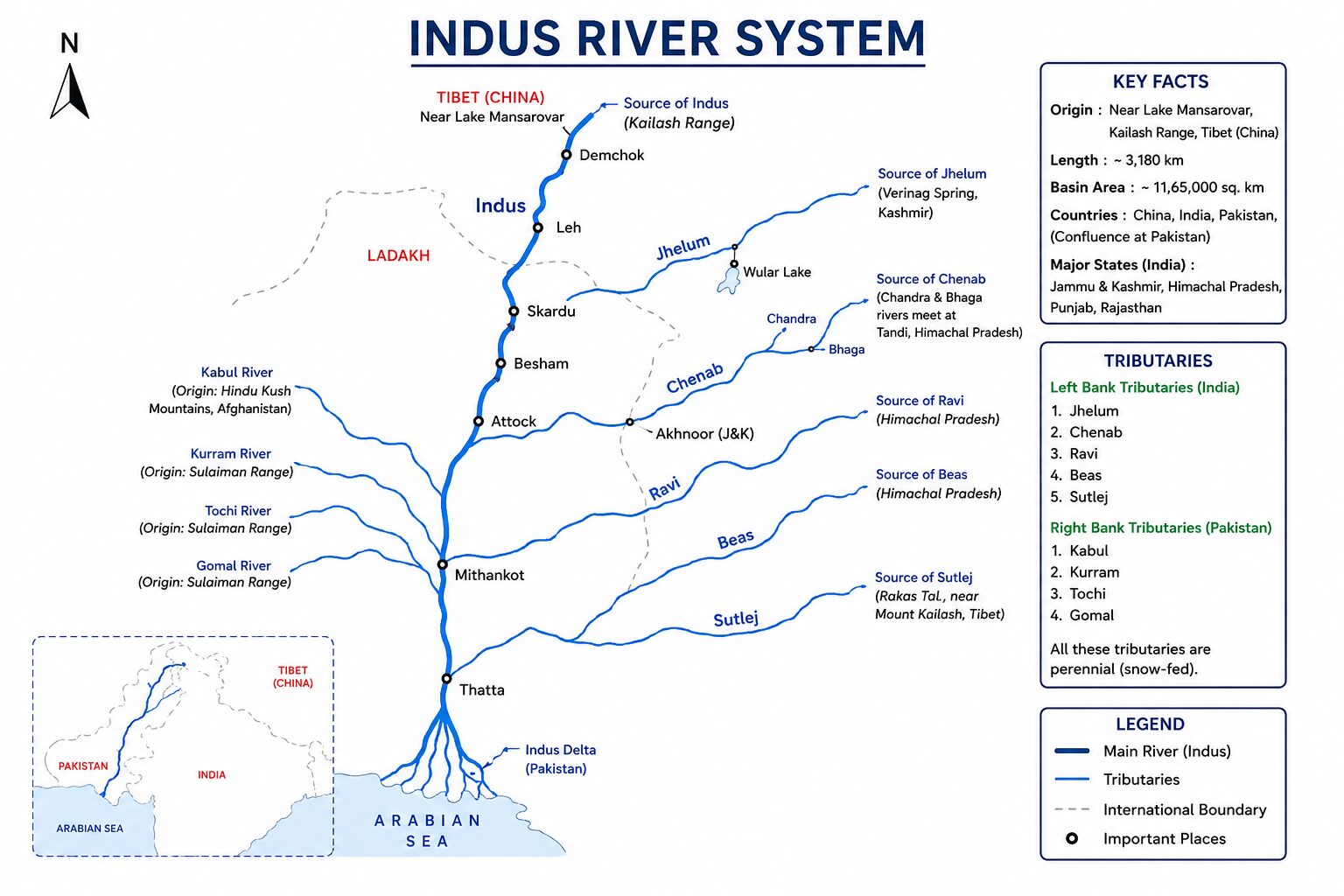
Major Tributaries of the Indus River System
The tributaries of the Indus are broadly classified into Right Bank (originating in the Himalayas, Karakoram, and Hindu Kush) and Left Bank (originating in the Himalayas and Zanskar ranges).
Right Bank Tributaries
These rivers primarily join the Indus in the mountainous regions of Ladakh, Gilgit, and Pakistan.
- Shyok: Known as the “River of Death,” it originates from the Rimo Glacier and is a major tributary of the Indus in Ladakh. The Nubra River (originating from the Siachen Glacier) is a major tributary of the Shyok.
- Gilgit: Joins the Indus near its great bend at Nanga Parbat.
- Kabul: Originates in Afghanistan and joins the Indus near Attock (Pakistan). Its main tributary is the Swat river.
- Other Right Bank Rivers: Hunza, Kurram, Tochi, and Gomal.
Left Bank Tributaries (The “Panjnad” Rivers)
These are the famous five rivers of Punjab that eventually merge to form the Panjnad (Five Rivers) before meeting the Indus at Mithankot in Pakistan. Another major left-bank tributary in Ladakh is the Zanskar River, which meets the Indus at Nimmu.
| River | Origin Point | Key UPSC Geographical Facts |
| Jhelum (Vitasta) | Verinag Spring (Pir Panjal, J&K) | Flows through the spectacular Kashmir Valley and Wular Lake. It forms the India-Pakistan border for a short stretch before entering Pakistan. |
| Chenab (Asikni) | Bara Lacha Pass (Himachal Pradesh) | Largest tributary of the Indus by water volume. Formed by the confluence of two streams: the Chandra and the Bhaga (Chandrabhaga). |
| Ravi (Parushni) | Rohtang Pass (Kullu Hills, HP) | Drains the area between the Pir Panjal and Dhauladhar ranges. Flows through the Chamba valley. |
| Beas (Vipasha) | Beas Kund (near Rohtang Pass, HP) | Lies entirely within Indian territory. It meets the Sutlej river at Harike in Punjab. |
| Sutlej (Shatadru) | Rakas Lake (Tibet) | An antecedent river. It enters India through the Shipki La Pass in Himachal Pradesh. |
The Indus Water Treaty (1960)
You cannot study the Indus River System for UPSC without understanding the geopolitics of water sharing between India and Pakistan.
Brokered by the World Bank, the Indus Water Treaty divides the six major rivers into two categories:
- Eastern Rivers (Ravi, Beas, Sutlej): India has absolute, unrestricted control over the waters of these three rivers.
- Western Rivers (Indus, Jhelum, Chenab): Allocated to Pakistan. However, India is permitted limited agricultural use and “non-consumptive” uses, such as building run-of-the-river (RoR) hydroelectric projects, provided they do not significantly alter the water flow.
This treaty is frequently in the news due to Pakistan’s objections to India’s dam constructions on the Chenab and Jhelum rivers.
Indus River System: Major Hydroelectric and Irrigation Projects
India has developed extensive infrastructure on these rivers for irrigation and power generation. Matching rivers to their respective dams is a favorite UPSC Prelims question format.
Hydroelectric Projects on Western Rivers (Permitted under IWT)
- On Jhelum:
- Uri Hydroelectric Project: A run-of-the-river project in Baramulla.
- Kishanganga Project: Built on the Kishanganga river (a tributary of Jhelum, known as Neelum in Pakistan).
- Tulbul Navigation Project: A barrage at the mouth of Wular Lake (currently suspended due to disputes).
- On Chenab:
- Salal Dam: Run-of-the-river project in Reasi district.
- Baglihar Dam: Located in the Ramban district.
- Dulhasti Dam: Located in the Kishtwar district.
- Ratle & Pakal Dul: Major upcoming projects heavily contested by Pakistan.
Projects on Eastern Rivers
- On Ravi:
- Ranjit Sagar Dam (Thein Dam): Located on the border of Punjab and J&K.
- Shahpur Kandi Barrage: Currently under construction to utilize India’s full share of the Ravi river.
- On Beas:
- Pong Dam (Maharana Pratap Sagar): An earth-fill dam in Himachal Pradesh.
- Pandoh Dam: Diverts Beas water to the Sutlej river to generate power.
- On Sutlej:
- Bhakra Nangal Dam: One of the highest gravity dams in the world. Its reservoir is called Gobind Sagar Lake.
- Nathpa Jhakri Dam: A major concrete gravity dam in Himachal Pradesh.
Major Irrigation Networks
- Indira Gandhi Canal: The longest canal in India. It starts from the Harike Barrage (the confluence of Beas and Sutlej in Punjab) and brings critical irrigation water to the Thar Desert in Rajasthan.
- Upper Bari Doab Canal (UBDC): Originates from the Ravi river at Madhopur, heavily irrigating the Punjab plains.
Biodiversity and Ecology of the Indus Basin
The Indus basin supports incredibly diverse ecosystems, ranging from the high-altitude cold deserts of Ladakh to the fertile wetlands of Punjab.
1. The Indus River Dolphin (Bhulan)
- Scientific Name: Platanista minor
- Status: Endangered (IUCN Red List).
- Characteristics: It is a functionally blind freshwater dolphin that relies entirely on echolocation to navigate and hunt.
- Habitat in India: While primarily found in the lower Indus in Pakistan, a small, isolated population was discovered in the Beas River in Punjab, India.
- Conservation: Punjab declared the Indus River Dolphin as its State Aquatic Animal in 2019. WWF-India works actively to conserve this fragmented population.
2. High Altitude Fauna
The upper catchments of the Indus (Ladakh and Spiti) are habitats for the elusive Snow Leopard (Vulnerable), the Himalayan Brown Bear, and the Tibetan Wolf. The Hemis National Park (India’s largest national park) falls within the Indus catchment area.
3. Crucial Wetlands (Ramsar Sites)
The rivers of Punjab create massive wetlands that serve as crucial wintering grounds for migratory birds traveling via the Central Asian Flyway.
- Harike Wetland: Confluence of Beas and Sutlej. Famous for wintering water-fowl.
- Kanjli Wetland: Located on the Kali Bein river (a tributary of Beas).
- Ropar Wetland: Located on the Sutlej river.
Development and Rejuvenation Challenges
Unlike the Ganga, which has a dedicated “Namami Gange” program, the rejuvenation of the Indus basin in India is handled through state-specific watershed management and pollution control boards.
- Industrial Pollution in Punjab: The Buddha Nullah, a highly polluted seasonal stream in Ludhiana, carries heavy metals and industrial effluents directly into the Sutlej River. Cleaning the Buddha Nullah is currently the most critical rejuvenation project in the state.
- Uranium Contamination: Parts of the Malwa region in Punjab face severe groundwater contamination (uranium and arsenic) linked to the canal networks and intensive agricultural runoff from the Green Revolution.
- Ecological Flow Issues: The extensive damming of the eastern rivers (Ravi, Beas, Sutlej) means that almost no water flows into Pakistan during the dry season, leading to dried-up riverbeds and ecological destruction downstream of the barrages.
Major Hydroelectric and Irrigation Projects on the Indus River System
India’s strategy for the Indus basin involves a two-pronged approach: aggressively building run-of-the-river (RoR) projects on the Western Rivers (as permitted by the Indus Water Treaty) and maximizing storage and irrigation on the Eastern Rivers.
1. Strategic Projects on Western Rivers (Indus, Jhelum, Chenab)
India is allowed limited, “non-consumptive” use of these rivers. The Chenab river, due to its massive water volume and steep gradient, is the primary focus of India’s hydropower push in Jammu & Kashmir.
- Kishanganga Hydroelectric Project (330 MW): Located on the Kishanganga river (a tributary of the Jhelum, called Neelum in Pakistan) in Bandipora district. It diverts water through a tunnel into the Wular Lake. Pakistan constructed the downstream Neelum-Jhelum project and heavily objected to India’s dam.
- Ratle Hydroelectric Project (850 MW): A massive run-of-the-river project under construction on the Chenab river in Kishtwar district.
- Pakal Dul (1,000 MW), Kiru (624 MW), and Kwar (540 MW): These are a cascade of high-capacity projects being rapidly constructed on the Chenab and its tributary, the Marusudar river. Their commissioning will massively boost J&K’s power generation capacity.
- Tulbul Navigation Project: A “navigation lock-cum-control structure” at the mouth of Wular Lake on the Jhelum. India calls it a navigation project, while Pakistan calls it the “Wular Barrage” and alleges it violates the treaty by creating storage. Work remains suspended.
2. Total Utilization Projects on Eastern Rivers (Ravi, Beas, Sutlej)
India holds 100% unrestricted rights over these rivers. While the Bhakra Nangal (Sutlej) and Pong (Beas) dams have long been operational, India historically allowed some surplus water from the Ravi to flow into Pakistan. India is now executing terminal projects to halt this entirely.
- Shahpur Kandi Barrage (Pathankot, Punjab): Declared a National Project, this multi-purpose dam on the Ravi River, downstream of the Ranjit Sagar Dam, is slated for completion in March 2026. From April 2026, it will completely halt the unutilized surplus water of the Ravi from flowing into Pakistan, diverting it instead to irrigate the Kathua and Samba districts of J&K and border areas of Punjab.
- Ujh Multipurpose Project: Planned on the Ujh river (a major tributary of the Ravi) in the Kathua district of J&K. It aims to store water for irrigation and hydropower before the river crosses the border.
- Beas-Sutlej Link & Indira Gandhi Canal: These massive inter-basin transfer and canal systems ensure that the waters of the eastern rivers irrigate the semi-arid regions of Punjab, Haryana, and the Thar Desert in Rajasthan.
Conflicts and Hydropolitics: The Indus Water Treaty Dispute
The Indus Water Treaty (IWT), signed in 1960 and brokered by the World Bank, has survived three major wars between India and Pakistan. However, it is currently facing its most severe crisis due to state-sponsored terrorism and legal deadlocks.
1. The Weaponization of Water and the 2025 Treaty “Abeyance”
Water sharing cannot exist in a vacuum of regional security. Following the devastating Pahalgam terror attack in April 2025, New Delhi took an unprecedented diplomatic step: India unilaterally placed the Indus Waters Treaty in “abeyance” until Pakistan credibly and irrevocably dismantles its cross-border terror infrastructure.
- The Repercussion: As a result of this abeyance, India has suspended the routine sharing of hydrological data and monsoon flood warnings with Pakistan through the Indus Water Commissioners, leaving Pakistan’s downstream infrastructure highly vulnerable to seasonal disasters.
2. The Legal Deadlock: Court of Arbitration vs. Neutral Expert
The dispute resolution mechanism of the IWT has completely fractured over India’s Kishanganga and Ratle projects.
- Pakistan’s Stance: Pakistan bypassed intermediate steps and approached the World Bank for a Court of Arbitration (CoA) to halt India’s dam designs.
- India’s Stance: India argued that technical design disputes must first be handled by a Neutral Expert, as per the treaty’s graded mechanism.
- The World Bank’s Blunder: The World Bank inexplicably initiated both processes simultaneously. In January 2025, the Neutral Expert confirmed his competence to hear the case, which India welcomed. However, in June 2025, the illegally constituted Court of Arbitration (at The Hague) issued a “supplemental award.” India categorically rejected this award, maintaining that the parallel CoA proceedings are a severe breach of the IWT and hold no legal validity.
Future Prospects & Climate Change Vulnerabilities
The future of the Indus River System is threatened by both geopolitical intractability and profound ecological shifts.
- Renegotiation of the IWT: The 1960 treaty is purely a quantitative, partition-based agreement. It does not account for modern realities like climate change, groundwater depletion, or environmental flow. India has formally issued notices to Pakistan demanding the modification and modernization of the treaty, though Islamabad has resisted, fearing a loss of its 80% water allocation.
- Accelerated Glacial Melt: The Indus is heavily dependent on glacial meltwater from the Hindu Kush, Karakoram, and Himalayan (HKH) ranges. Studies indicate that the basin has lost nearly 25% of its perennial snow and ice cover over the last two decades. While this may cause short-term flooding and increased river discharge, it will inevitably lead to severe long-term water scarcity.
- Pakistan’s Existential Water Crisis: Agriculture accounts for ~23% of Pakistan’s GDP, and 90% of it relies on the Indus system. Pakistan suffers from chronic domestic water mismanagement; its major reservoirs (Tarbela and Mangla) are heavily silted and often near dead storage. As India aggressively harnesses its legal share of the water and climate change reduces overall basin flow, Pakistan faces an existential food and economic security crisis.
Learn More about River Systems: Read about the Ganga River System in detail here
Learn More about River Systems: Explore all Major River Systems of India
