

Himalayas
The Himalayan mountain system represents the youngest, tallest, and most geologically dynamic mountain chain on the planet. Stretching over an arc of approximately 2,400 kilometers from the Indus Gorge in the west to the Brahmaputra Gorge in the east, this colossal physical barrier defines the geographical, climatic, and cultural boundaries of the Indian subcontinent.
For UPSC/UPPSC Civil Services aspirants, the Himalayas are a high-yield core topic that intersects physical geography, geomorphology, environmental ecology, biodiversity conservation, and strategic geopolitics.
Tectonic Evolution and Structural Architecture
The origin of the Himalayas is rooted in the dynamic theories of continental drift and plate tectonics:
- Pangea Fragmentation: During the Mesozoic Era, the supercontinent Pangea broke apart, separating the northern landmass of Laurasia (Angaraland) from the southern supercontinent of Gondwanaland. The vast, shallow Tethys Sea separated these two giant continental plates.
- Northward Migration: Approximately 200 million years ago, the Indo-Australian Plate broke away from Gondwanaland and began a rapid northward migration toward the massive Eurasian Plate at a rate of roughly 9 to 16 centimeters per year.
- Sedimentary Compression: As the Indian plate advanced, the marine sediments accumulated on the floor of the Tethys Sea were subjected to intense gravitational and lateral compressive forces.
- Continental Collision: By the Eocene epoch (around 50 million years ago), the continental-continental convergence of the Indian and Eurasian plates initiated the closure of the Tethys Sea. Because both plates were composed of relatively light, buoyant continental crust, neither could undergo deep subduction into the mantle.
- Orogenic Phasing: The intense collision caused the intervening Tethyan sedimentary rocks to buckle, fold, and thrust upward. This orogenic process occurred in three distinct geological phases:
- Greater Himalayas: Formed first during the Oligocene epoch.
- Lesser Himalayas: Uplifted during the Miocene epoch.
- Outer Shiwaliks: Formed during the late Pliocene and early Pleistocene epochs.
- Active Upliftment: Because the Indian plate continues to drive northward into Eurasia at a rate of about 5 centimeters per year, the Himalayas are still rising by a few millimeters annually, making the entire region seismically volatile and susceptible to high-magnitude earthquakes.
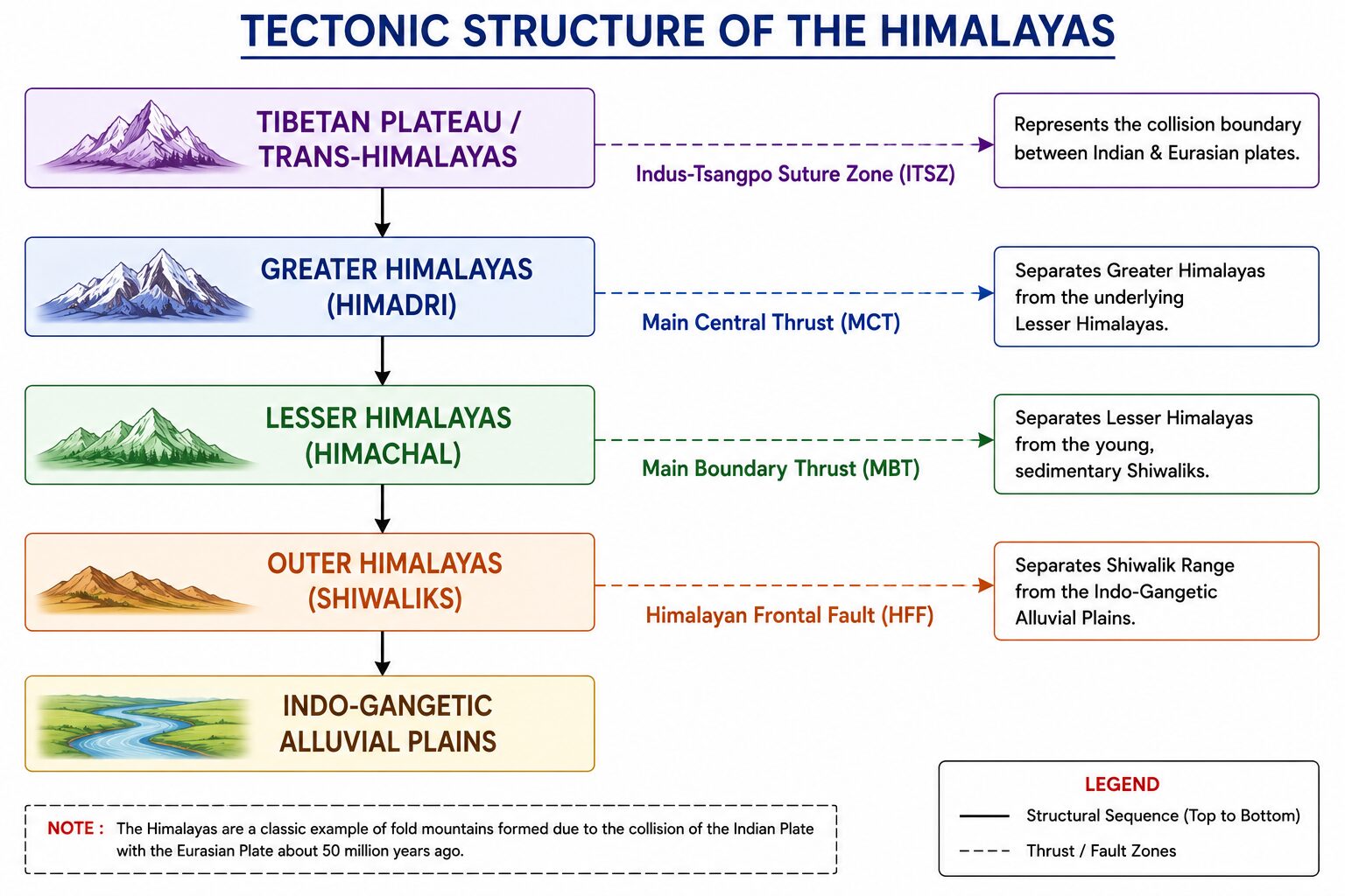
Longitudinal (North to South) Stratigraphic Division
The Himalayan architecture is divided into four distinct, parallel longitudinal mountain belts running from west to east, separated by major geological thrust faults and tectonic boundaries.
1. The Trans-Himalayas (Tibetan Himalayas)
- Geographical Position: Situated immediately north of the Greater Himalayan range, lying largely within the Tibetan Plateau and the northernmost extremities of Ladakh and Himachal Pradesh.
- Geological Composition: Composed of ancient granites, metamorphic rocks, and marine fossiliferous sediments of the Tethys Sea.
- Elevation and Climate: The average elevation exceeds 3,000 meters. The region is characterized by extreme aridity, freezing temperatures, and cold desert topography.
- Major Ranges: Encompasses the Karakoram Range, the Ladakh Range, the Zanskar Range, and the Kailash Range.
- Key Features: The Karakoram Range houses the world’s second-highest peak, K2 (Godwin-Austen), standing at 8,611 meters, alongside massive alpine glaciers such as the Siachen, Baltoro, Hispar, and Biafo glaciers. The Ladakh Range lies north of the Indus River, while the Zanskar Range lies to its south.
2. The Greater Himalayas (Himadri / Inner Himalayas)
- Geographical Position: The continuous, towering backbone of the mountain system, stretching from Nanga Parbat in the west to Namcha Barwa in the east.
- Dimensions: Boasts an average elevation of 6,100 meters and an average width of 120 to 190 kilometers.
- Geological Composition: Composed predominantly of Archaean granites, gneisses, and schists overlaid by highly metamorphosed sediments.
- Highest Summits: Perennially snow-capped, it houses the highest peaks on Earth, including Mt. Everest (8,848.86 meters), Kanchenjunga, Makalu, Dhaulagiri, Manaslu, Nanga Parbat, and Annapurna.
- Topographic Profile: Characterized by asymmetrical slopes—the southern slopes facing India are steep and rugged due to intense thrusting and erosion, while the northern slopes descending into Tibet are comparatively gentle. Major glacier systems, including the Gangotri, Yamunotri, Milam, and Zemu glaciers, originate in this zone.
3. The Lesser Himalayas (Himachal / Middle Himalayas)
- Geographical Position: Lying parallel and south of the Greater Himalayas.
- Dimensions: Average elevation ranges from 3,700 to 4,500 meters, with an average width of 60 to 80 kilometers.
- Geological Composition: Composed of highly compressed and altered rocks, including limestones, quartzites, slates, and metamorphic schists.
- Major Ranges: Heavily dissected and fragmented by major antecedent rivers. Prominent ranges include the Pir Panjal Range (longest range, situated in J&K and HP), the Dhauladhar Range (HP), the Mussoorie and Nag Tibba ranges (Uttarakhand), and the Mahabharat Lekh (Nepal).
- Valleys and Hill Stations: Celebrated for its scenic longitudinal valleys, such as the Vale of Kashmir, the Kangra Valley, and the Kullu Valley, as well as renowned hill stations like Shimla, Mussoorie, Nainital, Darjeeling, and Dalhousie.
4. The Outer Himalayas (Shiwaliks / Sub-Himalayas)
- Geographical Position: The southernmost, youngest, and lowest belt of the Himalayan system.
- Dimensions: Elevations vary between 600 and 1,500 meters, and widths narrow from 50 kilometers in Himachal Pradesh to less than 15 kilometers in Arunachal Pradesh.
- Geological Composition: Composed of unconsolidated fluvial sediments, conglomerates, sandstones, and silts deposited by rushing Himalayan rivers during the late Tertiary and Quaternary periods.
- Geomorphological Vulnerability: Because these rocks are uncompacted, the Shiwaliks are highly susceptible to mass wasting, soil erosion, landslides, and gully formation.
- Northeastern Extensions: In the northeastern states, the Shiwaliks lose their physical distinctiveness and merge into fragmented ridges, appearing as the Dafla, Miri, Abor, and Mishmi hills in Arunachal Pradesh.
Tectonic Thrust Boundaries and Fault Lines
The longitudinal mountain belts are separated from one another by major tectonic faults and thrust boundaries running parallel across the mountain arc.
- Indus-Tsangpo Suture Zone (ITSZ): The northernmost fault line, marking the collision boundary between the Indian Plate and the Eurasian Plate. It separates the Trans-Himalayas from the Greater Himalayas.
- Main Central Thrust (MCT): A major structural fault zone that separates the towering, crystalline rock formations of the Greater Himalayas from the underlying stratified rocks of the Lesser Himalayas.
- Main Boundary Thrust (MBT): The tectonic fault plane that separates the Lesser Himalayas from the young, sedimentary formations of the Shiwalik Range.
- Himalayan Frontal Fault (HFF): The southernmost boundary fault where the Shiwalik hills end abruptly and give way to the flat alluvium of the Indo-Gangetic Plains.
The Formation of Duns and Duars
- River Obstruction: When rivers flowing from the Lesser Himalayas cut across the newly rising Shiwalik ranges, their courses were temporarily blocked, creating expansive structural lakes.
- Sediment Accumulation: Over long periods, these lakes were filled with thick deposits of fluvial silt, sand, and conglomerates brought down by the mountain streams.
- Erosional Breach: When the rivers eventually cut through the Shiwaliks, the lakes drained away, exposing broad, flat, highly fertile valleys.
- Regional Nomenclature: These flat structural valleys are known as Duns in the western and central Himalayas (e.g., Dehradun, Kotli Dun, Patli Dun) and Duars in the eastern Himalayas (e.g., the Bengal Duars, heavily utilized for commercial tea estates).
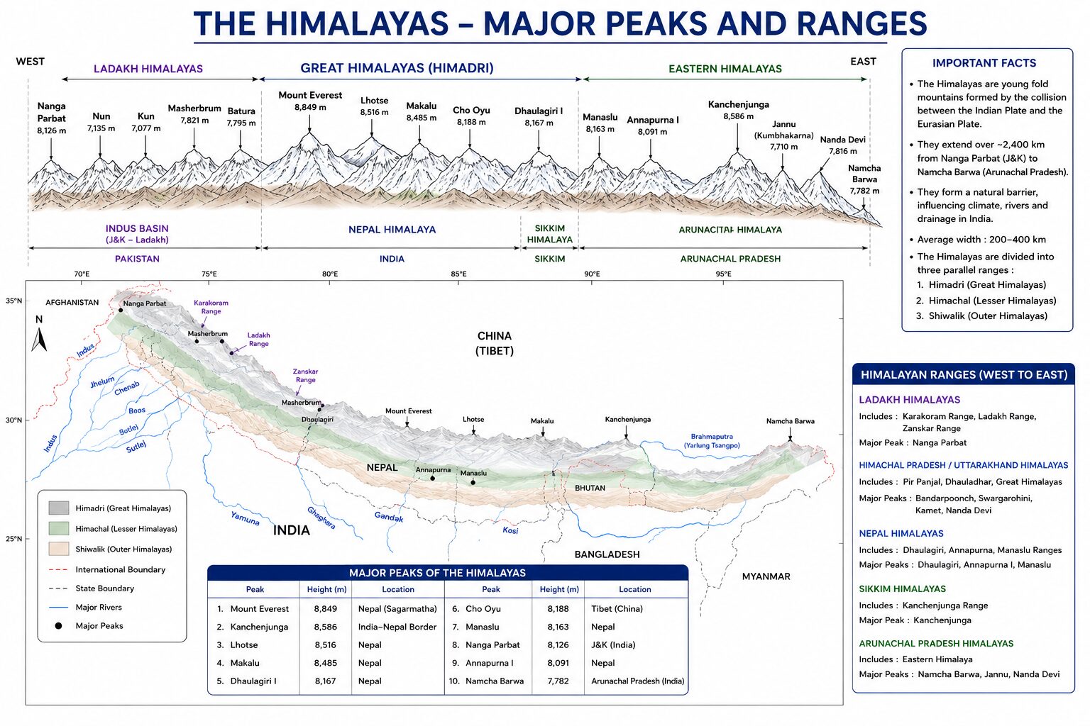
Regional (West to East) Classification of Himalayas
Sir Sydney Burrard classified the Himalayas on a regional basis, using major transverse river gorges as natural demarcating boundaries from west to east.
1. Punjab and Kashmir Himalayas
- Boundaries: Stretching over 560 kilometers between the Indus River gorge in Ladakh and the Sutlej River gorge in Himachal Pradesh.
- Key Ranges: Encompasses the Karakoram, Ladakh, Zanskar, and Pir Panjal ranges.
- Geographical Features: Characterized by broad mountain valleys and high-altitude cold deserts. It features the synclinal basin of the Vale of Kashmir, carved by the Jhelum River.
- The Karewa Formations: This region is unique for its Karewas—lacustrine (lake-deposited) glacial deposits of clay, silt, sand, and morainic gravel. These flat-topped terraces provide the exact well-drained, alkaline soil profile required for the cultivation of high-grade saffron (Crocus sativus), apples, and walnuts.
2. Kumaon and Garhwal Himalayas
- Boundaries: Extending roughly 320 kilometers between the Sutlej River and the Kali River (which forms the international boundary between Uttarakhand and Nepal).
- Key Summits: The western portion is known as the Garhwal Himalayas, while the eastern section is termed the Kumaon Himalayas. Major peaks include Nanda Devi (7,816 meters, the highest peak located entirely within India), Kamet, Trishul, Badrinath, Kedarnath, and Chaukhamba.
- Hydrological Significance: This region is the sacred birthplace of India’s most venerated river systems: the Bhagirathi originates from the Gangotri Glacier at Gaumukh, while the Alaknanda originates from the Satopanth Glacier, eventually merging at Devprayag to form the Ganga.
3. Nepal Himalayas
- Boundaries: Stretching over an impressive 800 kilometers between the Kali River in the west and the Testa River in the east.
- Key Summits: The tallest and most majestic section of the entire Himalayan arc. It houses the overwhelming majority of the world’s 8,000-meter peaks, including Mt. Everest, Kanchenjunga (8,586 meters, situated on the Sikkim-Nepal border), Lhotse, Makalu, Dhaulagiri, Cho Oyu, and Annapurna.
- Topographic Change: The Lesser Himalayas appear as the Mahabharat Range, while the Shiwaliks are largely absent or physically merged with the lesser ranges, allowing the Gangetic plains to transition almost immediately into towering mountain walls.
4. Assam and Eastern Himalayas
- Boundaries: Extending over 720 kilometers from the Testa River in Sikkim and West Bengal to the Dihang (Brahmaputra) gorge in Arunachal Pradesh.
- Climatic Influence: Due to its proximity to the Bay of Bengal, this zone receives exceptionally heavy annual rainfall exceeding 300 centimeters, resulting in intense fluvial erosion, deep gorges, and dense evergreen forests.
- Key Summits and Hills: Dominated by peaks like Namcha Barwa and Kangto. This zone is inhabited by diverse indigenous tribal communities residing in hills named after them, including the Aka, Dafla, Miri, Abor, and Mishmi hills.
5. The Purvanchal (Eastern Hills and Mountains)
- Boundaries: Beyond the Dihang gorge, the Himalayas execute a sharp southward bend, running along India’s eastern frontier with Myanmar.
- Key Hills: These medium-elevation hills are composed of strong sandstones and sedimentary rocks. They include the Patkai Bum hills, the Naga Hills (culminating in Saramati Peak at 3,826 meters), the Manipur Hills, and the Mizo or Lushai Hills in the south (featuring Phawngpui or Blue Mountain at 2,157 meters).
- Watershed Function: The Purvanchal acts as a crucial watershed separating the Indian drainage system from the Irrawaddy river basin of Myanmar.
Major Peaks of the Himalayan System
To excel in UPSC Prelims mapping and ordering questions, aspirants must be thoroughly familiar with the exact elevations, geographical locations, and regional alignments of the primary Himalayan summits.
| Mountain Peak | Elevation | Region / Country / State | Strategic & Geographical Significance |
| Mt. Everest (Sagarmatha) | 8,848.86 m | Nepal / Tibet Border | Highest peak on Earth; Lies in the Greater Himalayas. |
| K2 (Godwin-Austen) | 8,611 m | Karakoram Range (PoK / China Border) | Highest peak of the Karakoram range and second-highest globally. |
| Kanchenjunga | 8,586 m | Sikkim (India) / Nepal Border | Highest peak in undisputed Indian territory; Third highest globally. |
| Lhotse | 8,516 m | Nepal / Tibet Border | Fourth highest peak in the world; Connected to Everest via South Col. |
| Makalu | 8,485 m | Nepal / Tibet Border | Fifth highest mountain globally; Located southeast of Mt. Everest. |
| Dhaulagiri I | 8,167 m | Nepal Himalayas | Seventh highest peak; Separated from Annapurna by Kali Gandaki gorge. |
| Manaslu | 8,163 m | Nepal Himalayas | Eighth highest peak globally; Part of the Mansiri Himal sub-range. |
| Nanga Parbat | 8,126 m | Gilgit-Baltistan (PoK) | Ninth highest mountain; Marks the western syntaxial anchor of the arc. |
| Annapurna I | 8,091 m | Nepal Himalayas | Tenth highest peak globally; First 8,000-meter peak to be climbed (1950). |
| Namcha Barwa | 7,782 m | Tibet (China) / Arunachal Border | Marks the eastern syntaxial anchor where the Brahmaputra takes its sharp U-turn. |
| Nanda Devi | 7,816 m | Uttarakhand (India) | Highest peak located entirely within Indian borders; UNESCO Biosphere Reserve. |
| Kamet | 7,756 m | Garhwal, Uttarakhand (India) | Second highest mountain in the Garhwal region; Located in the Zanskar range. |
| Saramati | 3,826 m | Nagaland (India) | Highest peak of the Purvanchal and Naga Hills; Located on the Myanmar border. |
Himalayan River Systems and Drainage Architecture
The hydrological architecture of the Himalayas is fundamentally characterized by the presence of Antecedent Drainage Systems.
- The Antecedent Concept: An antecedent river is a watercourse that existed before the tectonic uplift of the mountain range across its path.
- Vertical Downcutting: As the Himalayan ranges rose over millions of years due to plate collision, these powerful rivers maintained their historical courses by downward vertical cutting and erosion at a pace matching or exceeding the rate of mountain uplift.
- Gorge Formation: Consequently, antecedent rivers slice straight through towering mountain walls, creating spectacular, vertical-sided, V-shaped canyons and gorges that can reach depths of thousands of meters. The most prominent antecedent rivers of the Himalayas include the Indus, the Sutlej, the Brahmaputra (Tsangpo), the Arun (a tributary of the Kosi), the Subansiri, and the Bhagirathi.
- Geomorphological Landforms: In their upper youth stages within the Himalayas, these rivers perform intense vertical erosion, creating distinctive geomorphological landforms such as steep V-shaped valleys, interlocking spurs, rapids, plunge pools, and waterfalls.
- Alluvial Depositions: As they emerge from the rugged mountain gorges onto the flat Indo-Gangetic plains at places like Haridwar and Rishikesh, their velocity drops abruptly, causing them to deposit their heavy coarse sediment loads to form expansive alluvial fans, braided channels, river terraces, and meanders.
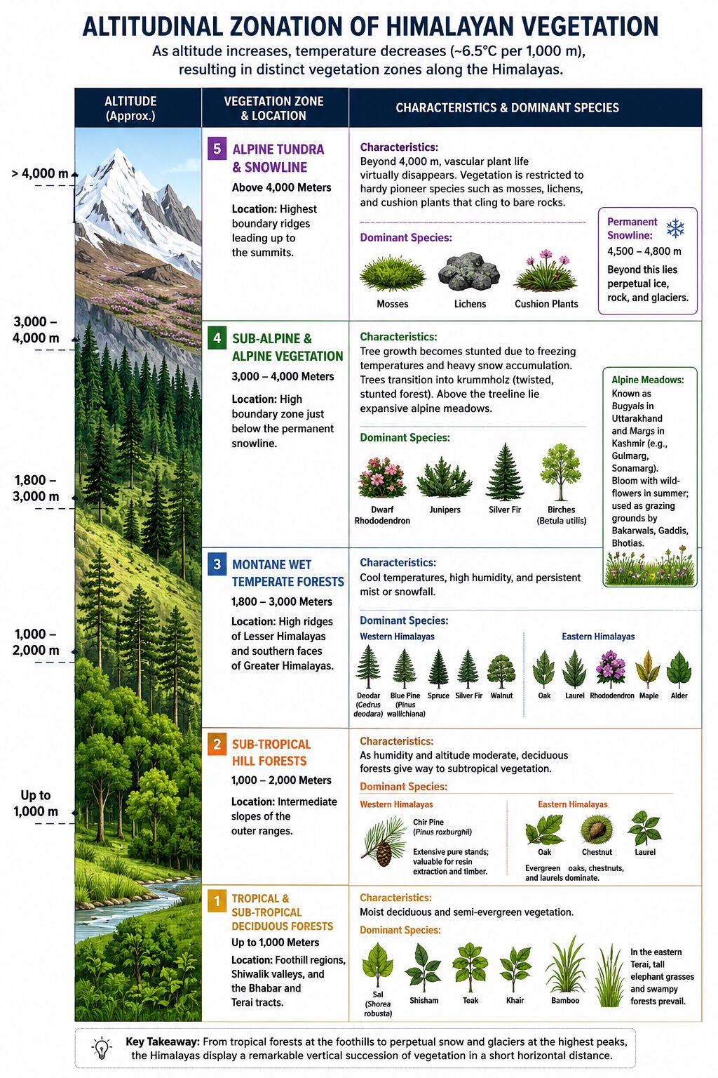
Altitudinal Zonation of Himalayan Vegetation
Because the Himalayas experience a drastic drop in temperature with increasing altitude—following the normal environmental lapse rate of approximately 6.5°C per 1,000 meters of ascent—the mountain range exhibits a condensed representation of almost all global vegetation zones.
1. Tropical and Sub-Tropical Deciduous Forests (Up to 1,000 Meters)
- Location: Dominated by the foothill regions, Shiwalik valleys, and the Bhabar and Terai tracts.
- Characteristics: Characterized by moist deciduous and semi-evergreen vegetation.
- Dominant Species: Sal (Shorea robusta) is the absolute dominant timber species, growing alongside Shisham, Teak, Khair, and Bamboo. In the eastern Terai, tall elephant grasses and swampy forests prevail.
2. Sub-Tropical Hill Forests (1,000 to 2,000 Meters)
- Location: The intermediate slopes of the outer ranges.
- Characteristics: As humidity and altitude moderate, deciduous forests give way to subtropical vegetation.
- Dominant Species: In the Western Himalayas, this zone is heavily dominated by extensive pure stands of Chir Pine (Pinus roxburghii), which is economically valuable for resin extraction and timber. In the wetter Eastern Himalayas, evergreen oaks, chestnuts, and laurels dominate the landscape.
3. Montane Wet Temperate Forests (1,800 to 3,000 Meters)
- Location: The high ridges of the Lesser Himalayas and the southern faces of the Greater Himalayas.
- Characteristics: This temperate belt experiences cool temperatures, high humidity, and persistent mist or snowfall.
- Dominant Species: In the Western Himalayas, this zone is celebrated for majestic stands of Deodar (Cedrus deodara), a highly prized, durable conifer endemic to the region, growing alongside Blue Pine (Pinus wallichiana), Spruce, Silver Fir, and Walnut. In the Eastern Himalayas, dense forests of oak, laurel, rhododendron, maple, and alder thrive.
4. Sub-Alpine and Alpine Vegetation (3,000 to 4,000 Meters)
- Location: The high boundary zone just below the permanent snowline.
- Characteristics: As elevation exceeds 3,000 meters, tree growth becomes stunted due to freezing temperatures and heavy snow accumulation. Trees transition into krummholz (twisted, stunted forest).
- Dominant Species: Consists of dwarf rhododendrons, junipers, silver firs, and birches (Betula utilis). Just above the treeline lie the expansive alpine meadows—known locally as Bugyals in Uttarakhand and Margs in Kashmir (such as Gulmarg and Sonamarg). These nutrient-rich pastures remain covered in snow during winter but bloom with vibrant wildflowers and herbs during summer, serving as grazing grounds for pastoral nomadic communities like the Bakarwals, Gaddis, and Bhotias.
5. Alpine Tundra and Snowline (Above 4,000 Meters)
- Location: The highest boundary ridges leading up to the summits.
- Characteristics: Beyond 4,000 meters, vascular plant life virtually disappears. Vegetation is restricted to hardy pioneer species such as mosses, lichens, and cushion plants that cling to bare rocks.
- The Permanent Snowline: At roughly 4,500 to 4,800 meters, the permanent snowline is reached, beyond which the landscape is blanketed in perpetual ice, rock, and glaciers.
Special Geomorphological Features of the Himalayas
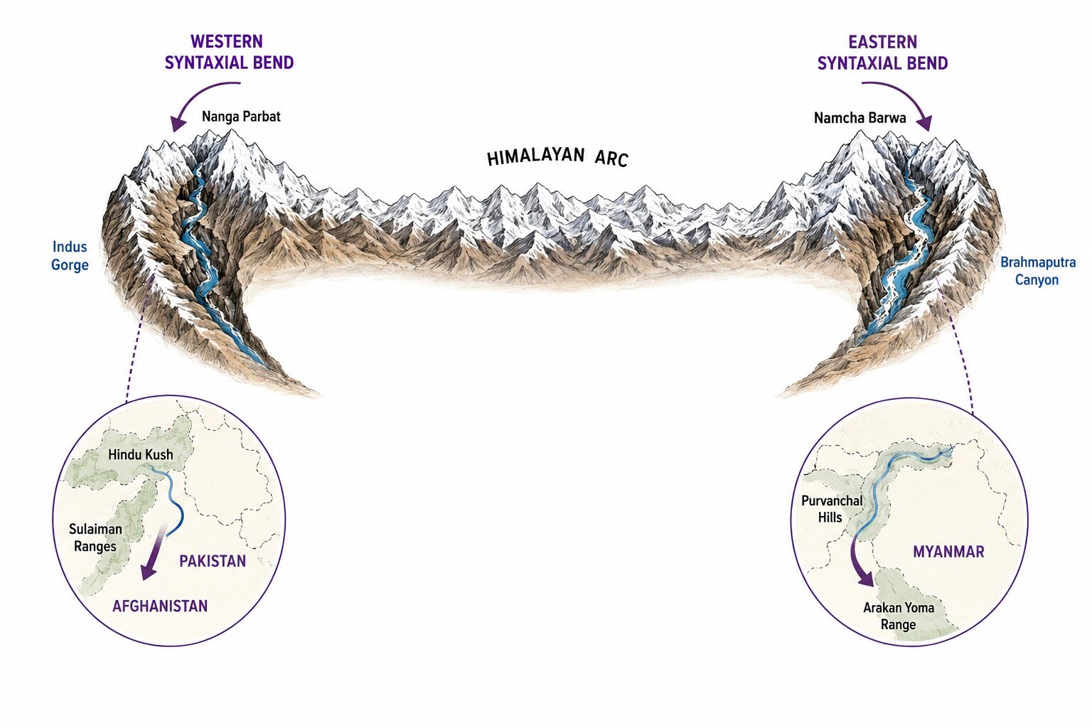
1. Syntaxial Bends (Hairpin Turns)
- The Concept: The Himalayan mountain arc does not terminate gradually; instead, at both its western and eastern extremities, the mountain ranges execute sharp, southward hairpin bends known as Syntaxial Bends.
- Western Syntaxial Bend: Occurs around the towering massif of Nanga Parbat where the Indus River cuts a profound gorge, turning the mountain trend sharply toward the south into Pakistan and Afghanistan (forming the Hindu Kush and Sulaiman ranges).
- Eastern Syntaxial Bend: Occurs around Namcha Barwa in Arunachal Pradesh where the Brahmaputra River carves a massive canyon, turning the mountain trend abruptly southward to form the Purvanchal hills and extending into the Arakan Yoma range of Myanmar.
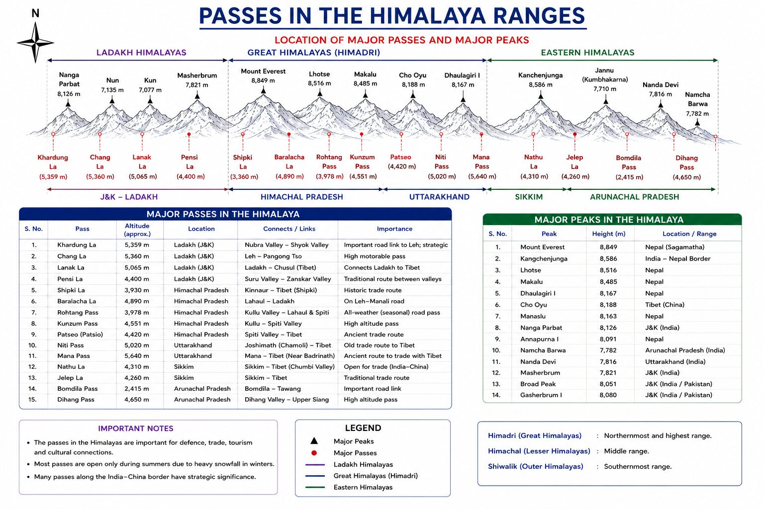
2. Strategic Himalayan Passes (La)
Mountain passes are structural saddles or depressions across elevated ridges that allow trans-Himalayan movement, trade, and military logistics.
- Zoji La (Ladakh): Located in the Zanskar range, this vital pass connects the Srinagar Valley to Kargil and Leh along National Highway 1.
- Banihal Pass (Jammu & Kashmir): Situated across the Pir Panjal Range at 2,832 meters, connecting the plains of Jammu to the Srinagar Valley; it houses the famous Jawahar Tunnel.
- Khardung La (Ladakh): Lying north of Leh in the Ladakh Range at 5,359 meters, it acts as the gateway to the Nubra and Siachen Glacier.
- Shipki La (Himachal Pradesh): Situated in the Zanskar range on the India-Tibet border through which the antecedent Sutlej River enters India from Tibet.
- Rohtang Pass (Himachal Pradesh): Lying across the eastern Pir Panjal Range, connecting the Kullu Valley with the Lahaul and Spiti valleys; bypassed by the strategic 9.02-kilometer Atal Tunnel.
- Lipulekh Pass (Uttarakhand): Located at the tri-junction of India, Nepal, and China (Tibet) in the Kumaon region; utilized by pilgrims traveling to Mount Kailash and Lake Mansarovar.
- Nathu La (Sikkim): Located on the Indo-China border, connecting Sikkim with the Chumbi Valley of Tibet; forms a critical, heavily guarded strategic trading border post.
- Bomdi La (Arunachal Pradesh): Lying at 2,217 meters, connecting the western boundary of Arunachal Pradesh (including Tawang Monastery) with Lhasa in Tibet.
Memory Tricks & Mnemonics
1. North-to-South Sequence of Himalayan Mountain Ranges
Mnemonic: “Kal Ladakh Zayenge Pir-Panjal Se”
(Tomorrow we will go to Ladakh via Pir Panjal)
Decoding:
K – Karakoram Range → L – Ladakh Range → Z – Zanskar Range → P – Pir Panjal Range → S – Shiwalik Range
Sequence:
Karakoram → Ladakh → Zanskar → Pir Panjal → Shiwalik
2. West-to-East Sequence of Regional Himalayan Divisions
Mnemonic: “Please Keep Nepal Afeem”
Decoding:
P – Punjab/Kashmir Himalayas (Indus to Sutlej) → K – Kumaon/Garhwal Himalayas (Sutlej to Kali) → N – Nepal Himalayas (Kali to Teesta) → A – Assam/Eastern Himalayas (Teesta to Dihang)
Sequence:
Punjab/Kashmir Himalayas → Kumaon/Garhwal Himalayas → Nepal Himalayas → Assam/Eastern Himalayas
3. West-to-East Sequence of Uttarakhand Panch Prayag
Mnemonic: “Vishnu Ne Karan Ko Rudra Aur Dev Banaya”
Decoding:
- Vishnuprayag – Alaknanda + Dhauliganga
- Nandprayag – Alaknanda + Nandakini
- Karnaprayag – Alaknanda + Pindar
- Rudraprayag – Alaknanda + Mandakini
- Devprayag – Alaknanda + Bhagirathi → Ganga
Sequence:
Vishnuprayag → Nandprayag → Karnaprayag → Rudraprayag → Devprayag
Quick Recall: V – N – K – R – D
Important Facts for Exams
- Tectonic Nature: The Himalayas are young, structurally folded mountains formed during the Tertiary Period by the collision of the Indo-Australian Plate and the Eurasian Plate.
- Highest Peaks: Kanchenjunga (8,586 m) in Sikkim is the highest peak in undisputed Indian territory. Nanda Devi (7,816 m) in Uttarakhand is the highest peak located entirely within India’s interior sovereign borders.
- Syntaxis Anchors: The western anchor of the Himalayan arc is Nanga Parbat (8,126 m), while the eastern anchor is Namcha Barwa (7,782 m).
- Karewas: Pleistocene lacustrine deposits found in the Kashmir Valley, globally critical for the cultivation of saffron (Crocus sativus) due to their fine silt and organic loam composition.
- Bugyals / Margs: High-altitude summer alpine pastures located between 3,000 and 4,000 meters, serving as seasonal grazing grounds for transhumant pastoralists like the Gaddis, Bakarwals, and Bhotias.
- Main Thrust Boundaries: The Main Central Thrust (MCT) separates the Greater Himalayas from the Lesser Himalayas; the Main Boundary Thrust (MBT) separates the Lesser Himalayas from the Shiwaliks; the Himalayan Frontal Fault (HFF) separates the Shiwaliks from the Northern Gangetic Plains.
- Duns and Duars: Longitudinal structural valleys formed between the Lesser Himalayas and Shiwaliks when rising ranges temporarily dammed river flows. Examples include Dehradun, Kotli Dun, and the tea-growing Bengal Duars.
- Treeline Anomaly: The treeline in the Eastern Himalayas extends up to approximately 3,800–4,000 meters, whereas in the Western Himalayas it ends at roughly 3,300–3,600 meters due to higher humidity, greater annual precipitation, and lower latitude in the east.
- Longest Glacier: The Siachen Glacier (76 km) in the Karakoram Range is the longest glacier in the Himalayas and the second-longest non-polar glacier in the world. The Gangotri Glacier (30 km) is the largest in the Garhwal Himalayas.
Going Good!!! Revise on the Go. Quickly Revise Indian River Systems before you move forward.
