

Ganga River System
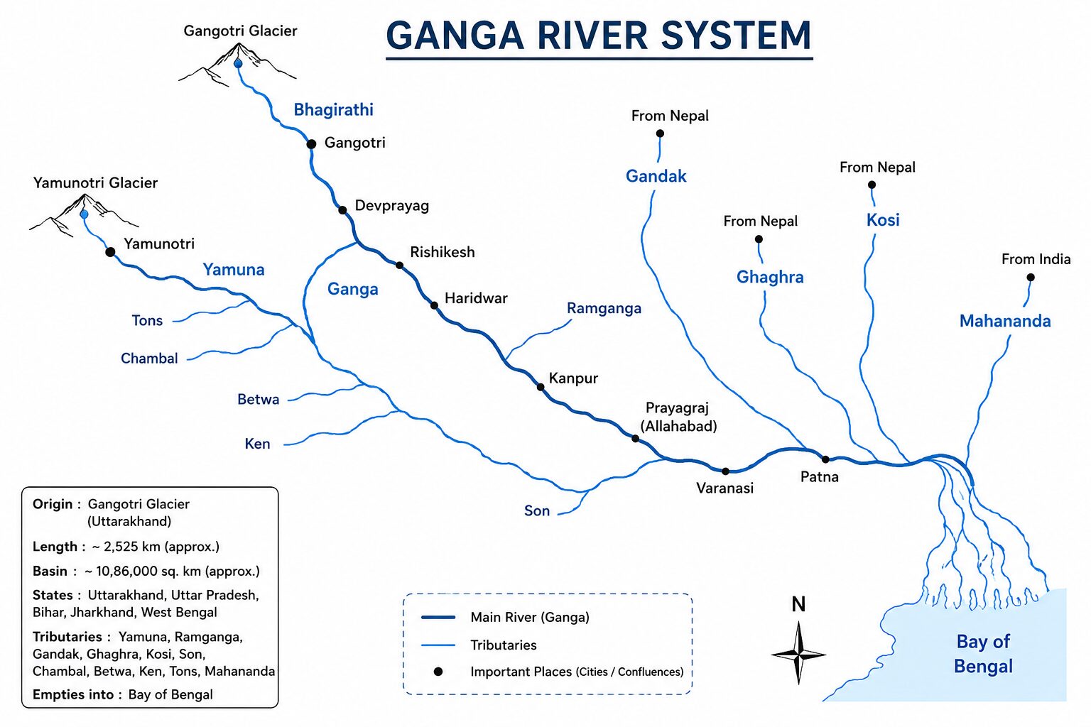
The Ganga River System is the largest and most vital river basin in India, covering roughly 26% of the country’s landmass and supporting over 40% of its population. For UPSC aspirants, understanding the geographical nuances, ecological significance, and developmental projects associated with the Ganga basin is essential for Prelims (mapping, ecology) and Mains (water management, environmental conservation, geography).
This exhaustive guide covers everything from the Panch Prayag to the Sundarbans delta, including a detailed breakdown of tributaries, biodiversity, and major infrastructure projects.
1. Origin and Course of the Ganga
The Ganga does not originate under the name “Ganga.” It is born from the confluence of several Himalayan streams in the state of Uttarakhand.
- Source: The headwaters, known as the Bhagirathi, originate from the Gangotri Glacier at Gaumukh (elevation of 3,900 m) in the Uttarkashi district of Uttarakhand.
- Total Length: 2,525 km.
- Basin States: Uttarakhand, Uttar Pradesh, Bihar, Jharkhand, and West Bengal (it also drains parts of Rajasthan, Haryana, Madhya Pradesh, Chhattisgarh, and Delhi via its tributaries).
- Discharge: Empties into the Bay of Bengal, forming the world’s largest delta, the Sundarbans (shared with the Brahmaputra).
The Panch Prayag (The Five Sacred Confluences)
Before descending into the plains at Haridwar, the river network is formed by the Alaknanda (originating from the Satopanth glacier above Badrinath) and its tributaries at five confluences:
- Vishnuprayag: Alaknanda + Dhauliganga
- Nandprayag: Alaknanda + Nandakini
- Karnaprayag: Alaknanda + Pindar
- Rudraprayag: Alaknanda + Mandakini
- Devprayag: Alaknanda + Bhagirathi
Key Fact: It is only after Devprayag that the combined stream is officially known as the Ganga.
2. Major Tributaries of the Ganga
The Ganga is fed by numerous Himalayan (perennial) and Peninsular (seasonal) rivers.
A. Left Bank Tributaries (West to East)
These originate primarily in the Himalayas and carry heavy sediment loads, often causing floods in the northern plains.
| Tributary | Origin | Key UPSC Facts |
|---|---|---|
| Ramganga | Garhwal district (Uttarakhand) | Flows through the Jim Corbett National Park. Joins Ganga near Kannauj. |
| Gomti | Gomat Taal, Pilibhit (Uttar Pradesh) | Only major Himalayan tributary originating in the plains, not mountains. Lucknow and Jaunpur are on its banks. |
| Ghaghara | Mapchachugo Glacier (Tibet) | Largest tributary of Ganga by water volume. Known as Karnali in Nepal. Joins Ganga at Chhapra (Bihar). |
| Gandak | Nepal Himalayas | Formed by Kali Gandaki and Trishuli. Joins Ganga near Sonpur (Bihar). |
| Kosi | Tibet/Nepal (Saptakoshi) | Known as the “Sorrow of Bihar” due to its braided channels and frequent shifting of course causing massive floods. |
| Mahananda | Darjeeling Hills (West Bengal) | The easternmost left-bank tributary of the Ganga in India. |
B. Right Bank Tributaries
These originate in the Peninsular plateau and the lower Himalayas.
| Tributary | Origin | Key UPSC Facts |
|---|---|---|
| Yamuna | Yamunotri Glacier (Bandarpunch peak) | Longest tributary of Ganga. Joins at Prayagraj (Triveni Sangam). Major sub-tributaries: Chambal, Sind, Betwa, Ken. |
| Son | Amarkantak Plateau (Madhya Pradesh) | Major south-to-north flowing river. Joins Ganga near Patna. Famous for gold dust in its sand. |
| Punpun | Palamu district (Jharkhand) | Joins the Ganga downstream of Patna at Fatuha. |
| Damodar | Chota Nagpur Plateau (Jharkhand) | Originally known as the “Sorrow of Bengal.” Joins the Hooghly (a distributary of Ganga) near Kolkata. |
3. Distributaries and the Delta
Upon reaching Farakka in West Bengal, the Ganga splits into two main branches:
- The Bhagirathi-Hooghly (in India): Flows southwards through West Bengal past Kolkata to empty into the Bay of Bengal at Sagar Island.
- The Padma (in Bangladesh): The main stream enters Bangladesh, joins the Jamuna (Brahmaputra) and the Meghna, and forms the massive Sundarbans Delta before draining into the sea.
4. Biodiversity of the Ganga Basin
The Ganga basin is an ecological hotspot, supporting a vast array of flora and fauna.
- Ganges River Dolphin (Platanista gangetica):
- India’s National Aquatic Animal.
- It is essentially blind (uses echolocation, known locally as Susu).
- IUCN Status: Endangered.
- An indicator species; its presence denotes a healthy river ecosystem.
- Gharial (Gavialis gangeticus): A fish-eating crocodile found in the Ganga system, primarily in the Chambal and Girwa rivers. IUCN Status: Critically Endangered.
- Turtles & Terrapins: The basin is home to the critically endangered Northern River Terrapin (Batagur baska) and the Three-striped Roofed Turtle.
- Avian Fauna: The basin supports wetlands like Kanwar Jheel (Bihar) and Nawabganj Bird Sanctuary (UP), hosting migratory birds like the Sarus Crane and Siberian ducks.
- Sundarbans Delta: The world’s largest contiguous mangrove forest. Home to the Royal Bengal Tiger, estuarine crocodiles, and the Sundari tree (Heritiera fomes).
5. Rejuvenation and Development Programs
Due to rapid urbanization, industrialization (especially tanneries in Kanpur), and agricultural runoff, the Ganga became highly polluted. The Government of India has launched several initiatives over the decades.
Historical Plans:
- Ganga Action Plan (GAP) Phase I (1985): The first major initiative aimed at improving water quality by intercepting, diverting, and treating domestic sewage.
- Ganga Action Plan Phase II (1993): Expanded to include tributaries like Yamuna, Gomti, and Damodar.
- National Ganga River Basin Authority (NGRBA, 2009): Shifted the approach from town-centric to a basin-wide planning approach.
Namami Gange Programme (2014 – Present)
An Integrated Conservation Mission with a budget outlay of ₹20,000 Crore to accomplish the twin objectives of effective abatement of pollution, and conservation and rejuvenation of the National River Ganga.
Key Pillars of Namami Gange:
- Sewerage Treatment Infrastructure: Creating STPs (Sewage Treatment Plants) across basin cities.
- River-Front Development: Constructing, repairing, and cleaning ghats.
- River Surface Cleaning: Collecting floating solid waste from the surface of the Ghats and River.
- Biodiversity Conservation: Breeding centers for Gharials, turtles, and dolphins.
- Afforestation: Planting trees along the banks to prevent soil erosion and maintain ecological balance.
- Public Awareness: Creating Ganga Praharis (volunteers) to educate the masses.
- Industrial Effluent Monitoring: Real-time monitoring of Grossly Polluting Industries (GPIs), especially paper mills and tanneries.
6. Major Water, Irrigation, and Hydroelectric Projects
The Ganga basin’s water resources are heavily managed for power generation, irrigation, and flood control.
A. Major Hydroelectric Projects (HEP)
- Tehri Dam (Uttarakhand): Highest dam in India (260.5 m). Located on the Bhagirathi River at its confluence with the Bhilangana. Generates 2,400 MW.
- Koteshwar Dam (Uttarakhand): Part of the Tehri Hydropower complex, situated on the Bhagirathi River.
- Tapovan Vishnugad HEP (Uttarakhand): A 520 MW run-of-river project on the Dhauliganga River. (Frequently in the news due to Himalayan glacial floods).
- Vishnuprayag HEP: Run-of-the-river project on the Alaknanda River.
B. Major Irrigation Projects and Barrages
- Farakka Barrage (West Bengal): Constructed across the Ganga near the Bangladesh border.
- Purpose: To divert water into the Hooghly river during the dry season to flush out silt and keep the Kolkata port navigable.
- UPSC Context: A major source of diplomatic tension and water-sharing treaties between India and Bangladesh.
- Upper, Middle, and Lower Ganga Canals: A massive network of irrigation canals originating from Haridwar, Bijnor, and Narora, respectively, turning the Doab region of UP into a highly fertile agricultural belt.
- Bansagar Dam (Madhya Pradesh): A multipurpose river valley project on the Son River, jointly shared by Madhya Pradesh, Uttar Pradesh, and Bihar.
- Rihand Dam / Govind Ballabh Pant Sagar (UP): Built on the Rihand River (a tributary of the Son). It is the largest artificial lake in India by volume.
- Matatila Dam & Rajghat Dam (UP/MP border): Situated on the Betwa River (Yamuna tributary), providing crucial irrigation to the drought-prone Bundelkhand region.
- Chambal Valley Projects: Gandhi Sagar (MP), Rana Pratap Sagar, and Jawahar Sagar (Rajasthan) dams built sequentially on the Chambal river for power and irrigation.
UPSC Strategy Takeaway
When preparing the Ganga River System, aspirants must interlink Geography with Environment and Current Affairs.
- For Prelims: Focus on the North-to-South or West-to-East arrangement of tributaries, the exact locations of the Panch Prayag, and national parks situated on these rivers (e.g., Corbett on Ramganga, Valmiki on Gandak).
- For Mains (GS 1 & GS 3): Be prepared to critically analyze the success of the Namami Gange project, the environmental impact of dams in the fragile Himalayan ecology (e.g., the Joshimath sinking issue linked to hydropower tunneling), and the geopolitical implications of the Farakka Barrage.
Read Here: All River Systems of India
